Urban Clustering in Java Island of Indonesia : Insights from Percolation Theory

Abstract
This study employs a percolation-based approach using road network data to analyze the impact of road network expansion on urban clustering across Java Island, Indonesia, from 2009 to 2023. The findings reveal that road network expansion has significantly altered urban cluster patterns in major cities throughout Java. The model indicates that at a 1000-meter threshold, the formation of urban clusters becomes distinctly observable, aligning with both satellite-based delineation of urban areas and flow-based identification of urban regions. Moreover, the percolation analysis demonstrates that Jakarta has expanded considerably beyond its administrative boundaries, encompassing Karawang and Purwakarta. This highlights the limitations of traditional methods that rely solely on administrative boundaries, which may underestimate the actual extent of urban clusters and impede effective regional planning and growth management. The analysis also suggests the potential for forecasting future urban expansion, which could lead to the merging of adjacent metropolitan areas. The integration of Jakarta-Bandung with more distant regions could give rise to a larger urban cluster, positioning Jakarta and its surroundings as the largest mega-urban area on Java Island. The merging of other metropolitan areas is also apparent in the case of Surabaya-Malang, where future urban expansion is likely to exceed current administrative boundaries. These findings highlight the need for integrated spatial policies that anticipate the effects of road network expansion on urban sprawl and facilitate effective growth management across administrative boundaries.
Keywords:
Urban Cluster, Percolation, Road Network, Spatial Boundary Delineation키워드:
도시권, 퍼콜레이션, 도로망, 공간적 경계 획정Ⅰ. Introduction
Despite comprising only 7% of Indonesia's land area, Java Island, home to many large cities, serves as the nation's demographic and economic center. It houses over half of the country's population and contributes 57.12% of the national GDP. Rapid economic and population growth in Java has accelerated urbanization and the expansion of large cities into sprawling metropolitan areas (Buchori et al., 2017). The rise of urban expansion in Java has led to the relocating of urban activities, such as housing, manufacturing, and business, from the city center to the outskirts (Mardiansjah et al., 2021). While this can enhance the regional economy, uncontrolled and uncoordinated urban growth triggers a significant shift from agricultural land to built-up areas (Rustiadi et al., 2021). The present urban spatial plan struggles to accommodate urban expansion, constrained by rigid jurisdictional boundaries, thereby impeding the development of an integrated spatial plan (Wirawan and Tambunan, 2018). As cities expand, their growth increasingly exceeds these outdated boundaries, making them less accurate and relevant (Bosker et al., 2021). In a narrow sense, this cannot properly represent the spatial extent of urban physical areas because the administrative area of a city can be much smaller than the urban physical area, or vice versa (Chen and Yeh, 2022).
In Indonesia, a metropolitan area is defined as a functional system with a population exceeding one million people, including an autonomous city and its surrounding urban areas spanning multiple regions. However, this definition overlooks the complete complexity of urban areas in Indonesia, which poses a barrier to achieving a nuanced understanding of the country's urban systems (Simatupang, 2008). Moreover, while official metropolitan boundaries may seem more desirable than administrative boundaries, they can still be susceptible to biases arising from political pressures in their delineation. This challenge may be exacerbated by the lack of transparency in the algorithms employed for their construction and the utilization of various predetermined criteria (Duranton, 2015a). The shortcomings of urban area definitions in Indonesia necessitate spatially explicit methods to redefine city boundaries by depicting urban clusters. This is essential to prevent biased interpretations of regional spatial interactions and to improve coordination and collaboration between cities and surrounding regions.
So far, only a few scholarly attempts to delineate urban clusters in Indonesia have been documented. Most of these studies have used administrative divisions, such as districts, to aggregate statistical data (Day and Ellis, 2014; Samad, 2012). The preferred approach to capturing the economic reality of cities and metropolitan areas often revolves around a functional area perspective based on commuting flow data (Freeman, 2004). However, obtaining such data can be challenging for many countries, especially those in the developing world (Bosker et al., 2021). Hence, to provide better descriptions of cities and metropolitan areas in these countries, much previous research has depended on alternative approaches that utilize more readily available data. Significant efforts have been made to utilize a morphological approach in describing cities and metropolitan areas in Indonesia (Buchori et al., 2017; Octifanny and Hudalah, 2017; Pravitasari et al., 2024). However, there has been minimal effort to define the resulting metropolitan areas in terms of the number and size of identified metro areas. Considering such limitations, a thorough understanding of the urban clusters boundary is vital for helping policymakers craft the most appropriate policies, especially in the realm of infrastructure for regional development.
This paper aims to identify urban clusters using a percolation approach with road network data in Java Island, Indonesia. The fundamental concept of percolation theory is to account for interconnections among elements forming clusters. Street networks are utilized to describe urban interactions and clusters, as most flows occur along these connecting elements (Arcaute et al., 2016). By applying this approach, we provide an alternative perspective for analyzing regional interactions and aim to effectively capture urban areas through existing road networks, associated economic activities, and population distribution.
We conducted a percolation analysis of the road network on Java Island for the years 2009 and 2023, examining changes in urban clusters over this period. Since the late 2000s, the government has resumed large-scale road infrastructure projects in Java Island, which continue to this day. Examining road network connectivity helps identify the true size of urban areas, as denser road networks usually indicate a higher concentration of urban development. Furthermore, the percolation model based on road networks offers a promising method for analyzing urban clusters in different geographic regions. This model distinguishes various levels of urban clusters and tracks their evolution over time, thereby contributing to the empirical literature on urban clusters in Java Island, Indonesia.
Ⅱ. Literature Review
1. Urban Cluster in Indonesia
Urban clusters, characterized by the clustering of cities and their contiguous growth, have been a focal point in empirical research due to their significant impact on economic dynamics. Larger populations in dense economic centers generate substantial positive externalities, including productivity gains, innovation, and overall economic growth. Kuncoro and Wahyuni (2009) found that manufacturing firms in Java tend to be located in more populous and densely populated areas to benefit from both localization and urbanization economies. Other research suggests that firms will continue to concentrate their operations in the more productive regions of Java, particularly in the Jakarta Metropolitan Area because these areas benefit from higher labor density and better urban infrastructure (Wibowo and Kudo, 2019).
Cities are actively expanding in pursuit of enhanced agglomeration economies (Fu et al., 2022). This represents a departure from earlier perspectives that viewed agglomeration externalities as confined to local impacts within city limits (Rosenthal and Strange, 2004). In contrast, contemporary research underscores the expanding influence of urban economic benefits, facilitated by globalization and regional integration. This interconnectedness allows these benefits to extend beyond city borders, fostering a spillover effect that stimulates development in adjacent regions (Rasmussen et al., 2016). Consequently, contiguous urban clusters are emerging as multiple cities grow together, amplifying their collective economic prowess (Fu et al., 2022).
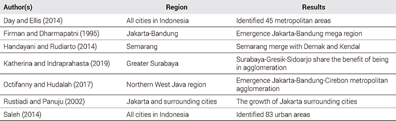
Driven by economic opportunities, numerous studies on urban dynamics in Java emphasize the expansion of metropolitan areas into adjacent cities (see <Table 1>). This expansion has the potential for further growth, potentially leading to the amalgamation of these areas into larger agglomerations (Firman, 2009, 2017; Octifanny and Hudalah, 2017; Pravitasari et al., 2024). However, delineating urban areas using government-assigned urban and metropolitan boundaries often fails to capture the true scale of urban growth (Bosker et al., 2021). These boundaries do not reflect the on-the-ground reality, where cities like Jakarta and Surabaya are increasingly merging with neighboring areas (Firman and Dharmapatni, 1995; Katherina and Indraprahasta, 2019).

Urban clusters in Indonesia
Several studies have explored the extent of urban clusters in Indonesia, specifically focusing on the densely populated island of Java. Saleh (2014) identified 83 metropolitan areas nationwide, with 42 concentrated in Java, using a two-component method based on existing administrative boundaries and statistical data. These areas were categorized into two types based on population size: metropolitan (exceeding one million people) and micropolitan (under one million people). This classification identified Jakarta, Surabaya, Semarang, Bandung, and Malang as the top five most populous metropolitan areas. In contrast, Day and Ellis (2014) identified 45 metropolitan areas across Indonesia (14 located in Java) by adopting an urban agglomeration index from previous literature. Their definition encompasses both single-city and multi-city areas at the core of multi-district metropolitan regions.
Researchers have also examined the phenomena focusing on individual cities in Java. Firman and Dharmapatni (1995) noted Jakarta's physical expansion, which has led to its integration with Bandung and blurred the rural-urban boundaries. Rustiadi and Panuju (2002) observed that Jakarta's growth extends beyond official boundaries into surrounding areas with diverse economic activities. Octifanny and Hudalah (2017) highlighted that megaprojects, foreign investment, and new regulations are key drivers of Jakarta's development, contributing to its merging process with Bandung and Cirebon.
This pattern of urban expansion also occurs in other cities outside Jakarta. Surabaya has similarly evolved into a specialized urban center with surrounding satellite cities (Katherina and Indraprahasta, 2019). Semarang’s population growth has extended into neighboring areas such as Demak, Semarang, and Kendal Districts (Handayani and Rudiarto, 2014). Wirawan and Tambunan (2018) emphasize the growth of small cities in Java, while Setyono et al. (2016) note that the Joglosemar growth triangle-comprising Semarang, Yogyakarta, and Surakarta-has stimulated the development of smaller cities that could evolve into larger urban areas.
Previous studies often aggregate economic and population data at the district level, which can obscure the true morphology of urban areas and lead to overestimation. This issue is particularly prevalent in developing countries like Indonesia, where administrative districts often encompass larger areas than actual neighborhoods. Additionally, defining urban areas using land-use data can be misleading, as built-up areas such as industrial zones, parks, and cemeteries do not always reflect core urban functions. This paper aims to expand the existing literature on urban clusters in Indonesia. Unlike previous studies, we will disregard predetermined administrative boundaries and instead use road network data to analyze urban interactions and agglomeration patterns in Java.
2. Empirical Approach Delineating Urban Clusters
Pinpointing the boundaries of urban clusters is crucial for studying city and regional growth, improving the understanding of development interrelations, and enabling effective planning. Urban clusters serve as a key policy tool for regional economic growth (Gao et al., 2015). However, the absence of a universally accepted standard for delineating these boundaries presents a challenge, leading to a relative and localized approach specific to each region or country (Pan et al., 2020).
Traditional methods typically use administrative units as the basis for delimiting and analyzing the spatial structure and scope of urban clusters through non-spatial characteristics. This approach lacks spatial context, limiting its applicability to planning and administration (Liang et al., 2010). Researchers often adopt a multifaceted approach, utilizing both morphological and functional criteria to delineate urban agglomeration boundaries (Skadins et al., 2019). The morphological approach focuses on the spatial structure of cities, examining the configuration of the built environment through land-use patterns (Burger and Meijers, 2012). In contrast, the functional approach explores how socioeconomic factors interact to shape the structure and dynamics of urban areas (Liang et al., 2010).
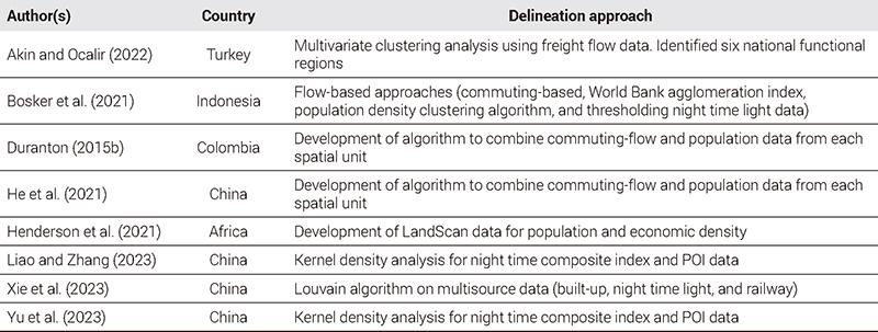
Prior studies have utilized commuting and flow data to delineate urban clusters and metropolitan areas, improving city and regional descriptions (Akin and Ocalir, 2022; Bosker et al., 2021; Duranton, 2015b; He et al., 2021). Akin and Ocalir (2022) defined functional regions and megaregions in Turkey using intercity freight flow patterns and economic indicators. Bosker et al. (2021) employed daily Origin-Destination (O-D) flow data to analyze worker movements between districts in Indonesia. Duranton (2015b) used labor commuting patterns to delineate metropolitan areas in Colombia. He et al. (2021) suggested that wavelet transform analysis of population movement data enhances the understanding of city interconnections and urban cluster boundaries. However, obtaining round-trip flow data can be challenging, especially in developing countries, and reliance on administrative boundaries may limit the effectiveness of flow-based approaches (Bosker et al., 2021; Dingel et al., 2021).
When commuting flow data is limited, alternative methods are often used to delineate cities and metropolitan areas. Henderson et al. (2021) used population data to identify urban areas and measure density in six African countries, finding it effective for fine-scale population estimates. Xie et al. (2023) employed multisource data, including nighttime light, built-up areas, and railways, to track expansion in eastern China, effectively identifying core cities. Yu et al. (2023) combined Point of Interest (POI) and Nighttime Light (NTL) data to define China’s rural-urban peripheries, noting that this approach surpasses population density data in accuracy by leveraging differences in facility type, light intensity, and resolution. Liao and Zhang (2023) used land use data to study urbanization in China’s urban agglomerations. While these methods complement traditional data, they offer limited insight into regional functional relationships. Therefore, assessing connectivity-how different urban spaces are linked-becomes crucial in this context.
Various empirical methods have been employed to explore the complexity of urban environments (see <Table 2>). Understanding the morphology of the urban core, which represents the origins of the urban system, is crucial for comprehending the historical processes that shaped its development. The emergence of the city can be viewed as a structural phase transition, marking a shift from isolated settlements to a cohesive urban system (Bitner et al., 2009). Previous research indicates that these patterns emerge at critical points in urban systems, where dispersed elements begin to form correlated clusters (Makse et al., 1998).
Urban cluster delineation approach
Since percolation can lead to various critical phenomena, urban researchers use percolation theory to model urban growth and gain insights into urban dynamics. Understanding spatial patterns in urban areas is crucial for grasping their organizational structure and the dynamics of interactions between spaces (Huynh and Ramli, 2022). The road network is pivotal for understanding landscape connectivity in urban systems, as it forms the foundational framework upon which cities are built (Huynh et al., 2018). Serving as the primary conduit for communication and exchange between settlements, it is essential for delineating flow-based functional areas and provides an alternative to limited commuting flow data (Ou et al., 2023).
Arcaute et al. (2016) extended the framework of percolation theory to the analysis of road networks. Their approach investigates whether the density of street intersections reflects a city's hierarchical structure. The underlying hypothesis is that road network density serves as a proxy for activity levels within the urban system (e.g., commuting, trade). Denser road networks are often indicative of higher economic concentration, paralleling the trends observed in classical percolation theory, where denser occupied sites facilitate the formation of large, interconnected clusters. Consequently, the application of percolation theory has been extended to the study of urban cluster areas.
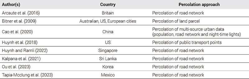
The percolation method has been widely used to analyze urban growth patterns in various countries (see <Table 3>). Tapia-Mcclung et al. (2023) applied percolation theory and fractal dimension analysis to Mexico's national road network to determine city boundaries. They found that the percolated network at the distance of maximum fractal dimension aligns well with actual built-up environmental data. Bitner et al. (2009) investigated the parcel morphology of core cities in Australia, the USA, and Europe, discovering that the morphology of these cities exhibits scaling behavior, reflecting the self-similar hierarchical spatial structure of urban systems. Huynh and Ramli (2022) applied the percolation methodology to Singapore's road network, identifying a critical spatial scale of 85 meters, which corresponds closely with local urban planning boundaries and reveals the city's essential connectivity structure. Kalpana et al. (2021) developed an intersection-based clustered network model (iCN Model) using percolation theory, demonstrating that the derived urban agglomeration pattern matches satellite imagery with over 71% accuracy (KAPPA). Huynh et al. (2018) analyzed the spatial patterns of 53 US cities by examining the distribution of public transport points. They found that these points generally fall into four categories: clustered, scattered, regularly distributed, or a combination thereof. Their findings suggest that urban systems can be classified into two types: well-planned and organically grown. Ou et al. (2023) used percolation on road networks to delineate functional regions in Korea, revealing an extremely Seoul-centered mono-centric structure with greater spatial coverage than conventionally assumed. Cao et al. (2020) proposed a percolation-based method to extract urban areas from multi-source data (population, roads, nighttime lights), validated against Landsat-based reference data in 10 cities, achieving improved accuracy through data fusion (κ= 0.69−0.85, mean κ= 0.78).
Application of percolation for delineation urban cluster
Ⅲ. Methodology
1. Percolation Method
Percolation theory originated in statistical physics and mathematics. Introduced in 1957 to understand fluid flow through porous materials, the theory examines how water infiltrates a material by forming continuous paths through interconnected pores (Grimmett, 1999). It has since evolved to study the formation of connected clusters on random graphs (Cao et al., 2020). Stauffer and Aharony (1994) provide a straightforward introduction by visualizing a large square lattice where some squares are occupied by sites while others remain vacant (see <Figure 1>). A crucial parameter is the occupation probability (p), which indicates the likelihood of a specific site being occupied. In this model, neighboring sites can form clusters if they share a common edge. A fundamental concept in percolation theory is the formation of clusters-groups of interconnected occupied sites.

Percolation on a square latticeSource: Adapted from Stauffer and Aharony (1994)
Percolation theory primarily examines how the probability (p) influences the appearance of an infinite cluster. To describe this phenomenon, one often uses the concept of the giant cluster, defined as
| (1) |
N is the size of the system (site number), and S₁ is the number of sites in the largest cluster.
A principal quantity of interest in percolation theory is the percolation probability, denoted by θ(p). This represents the probability that a given vertex is part of an infinite open cluster. Due to the translation invariance of the lattice and the probability measure, we can generalize this by selecting the origin as our reference point. Thus, θ(p) is defined as:
| (2) |
where (C) represents the cluster containing the origin, indicating the probability that the origin belongs to an infinite connected cluster.
It is straightforward to see that (|C|=∞) if and only if there exists an infinite sequence of distinct sites X0, X1, X2, ··· such that X0 = 0, Xi is adjacent to Xi+1, and the edge (Xi, Xi+1) is open for all i. Clearly, θ(p) is a non-decreasing function of p with θ(0) = 0 and θ(1) = 1.
As (p) increases, the system undergoes a dramatic shift in connectivity at the critical point or threshold (pc). (pc) is called the critical probability or critical threshold and is defined formally by:
| (3) |
Below this threshold, the percolation probability θ(p) remains low. Connected clusters tend to be small and isolated, making the formation of an infinite cluster spanning the entire lattice highly improbable. However, at (pc) a critical transition occurs. The percolation probability θ(p) experiences a significant jump, indicating that the formation of an infinite cluster becomes possible. As p increases beyond (pc), θ(p) continues to rise, reflecting a growing likelihood of encountering these large-scale connected structures.
Percolation theory finds broad application across various scientific disciplines. One notable application is in the forest fire model. In this model, the spread of a fire depends on the density of trees, represented by the probability (p) of finding a tree in a specific location. This scenario mirrors percolation processes, where clusters of nearby trees can propagate the fire throughout a forest. If these clusters span the entire forest, a fire can potentially burn the entire area; otherwise, it remains localized (Stauffer and Aharony, 1994). Similar principles apply to modeling the spread of epidemics, where infected individuals may spread disease to their neighbors probabilistically, illustrating another example of percolation-like behavior in real-world phenomena (Li et al., 2021).
A key advantage of the percolation method in this context is its data efficiency and inherent flexibility. Unlike other methods, it does not require prior assumptions about the number of clusters (such as city centers) within the network or their precise geographical boundaries. This flexibility makes it particularly suitable for analyzing complex urban systems. Consequently, the percolation method holds promise as a novel approach to delineating urban clusters, especially when compared to traditional methods based on administrative boundaries. The percolation method can capture the interconnectedness of urban areas, providing more detailed insights into their true connectivity. By simulating a percolation process, where elements become interconnected based on a specified threshold, the method can identify clusters of urban development that may transcend administrative boundaries.
2. Data
The main data used in the percolation analysis to identify urban clusters on Java Island, Indonesia, consists of road network shapefiles provided by the Indonesian Geospatial Information Agency for the years 2009 and 2023. The initial dataset includes over 2 million road lines and intersections. For analysis purposes, however, we focus only on road types suitable for four-wheeled vehicles, excluding roads narrower than 4 meters (Ou et al., 2023), as roads wider than 4 meters are classified as connecting various activity centers. Our analysis includes 213,920 nodes and 290,752 links for 2009, and 504,318 nodes and 544,907 links for 2023.
The first step in the percolation analysis is to construct an undirected graph based on the points and lines of the road networks. In this graph, the points (nodes) represent road intersections, and the lines represent the roads. A crucial stage in transitioning from raw data to graphs involves creating an adjacency matrix. This matrix identifies adjacent node pairs and specifies the length of the links between them.
Once the road network is transformed into a graph, the percolation process is applied using a threshold distance. Following this process, a new graph emerges, comprising clusters of nodes that are accessible within the specified threshold distance. This threshold distance determines the range within which clustering can occur across different segments of the network. Links that are less than or equal to the threshold distance are considered connected, while those exceeding this distance are deemed disconnected and removed from the graph. The percolation process is iterated across various threshold distances, ranging from 100 meters to 2 kilometers. <Figure 2> illustrates a schematic representation of the sequential stages involved in this iterative percolation process. To evaluate the behavior of the percolation process, cumulative cluster sizes can be visualized on a map.

Schematic diagram of percolation process on road networks
3. Validation of the Percolation Model
The performance of the percolation model is evaluated using high-resolution gridded urban data, including population density and built-up areas. Population density is a key indicator for measuring urban growth (Henderson et al., 2021; Wirth, 1938) and, according to Chen et al. (2023), effectively reflects spatial agglomeration and economic dynamics in urban areas. We use LandScan population density data, a well-established global grid, to track changes in population distribution. Henderson et al. (2021) demonstrated its accuracy in estimating population at a fine spatial scale by applying it to urban areas in six African countries. According to Indonesia's Head of National Statistics Agency Decree No. 37/2010, an urbanized area is defined as having a population density exceeding 1,250 people/km2.
Another approach to assess the model's applicability in real-world scenarios is to compare predicted urban clusters with satellite images that classify urban areas (Kalpana et al., 2021). The Global Human Settlement Layer (GHSL) is a well-known global urban map used to evaluate the performance of the percolation results. The GHSL represents the distribution of built-up surfaces derived from Sentinel-2 composites and Landsat imagery. The GHSL built-up dataset, at a 1x1km resolution, quantifies global built-up area density. According to prior studies (Cao et al., 2020), regions with built-up density exceeding 20% are classified as urban areas in the GHSL dataset. Therefore, the data is reclassified based on this criterion. Many studies utilize this data due to its effectiveness in identifying urban areas (Cao et al., 2020; Tapia-McClung et al., 2023).
Additionally, we compare the percolated road network performance with reference maps of Java's urban clusters from previous research. Two such reference maps, based on recent commuting data, are provided by Bosker et al. (2021) and Day and Ellis (2014). We project the estimated clustered nodes onto a map of Java's administrative boundaries to delineate functional regions. City and county-level boundaries are used for this mapping, as these are the lowest-level administrative units in Indonesia with publicly elected leaders and regional autonomy.
We then conducted a similarity test using the Jaccard similarity index, a widely utilized metric for assessing similarity between pairs of model outputs (Bosker et al., 2021; Ou et al., 2023). Formally, if we denote the set of areas classified as urban in one map as A, and the set of areas classified as urban in a second map as B, then the Jaccard index is defined as:
| (4) |
This index measures the similarity between the two sets, where a value of 1 indicates perfect overlap and 0 indicates no overlap.
IV. Results
1. Clustering Patterns with Different Percolation Thresholds
The road network percolation analysis examined the evolution of clusters within specific threshold distances over two years. Threshold distances were determined using the methodology from Ou et al. (2023), which identifies major clusters at various distances. <Figure 3> displays changes in cluster sizes between 2009 and 2023, illustrating the expansion of the road network on Java Island over the decade.

Evolution of urban clusters in 2009 and 2023
Initially, a significant shift was observed at a threshold distance (td) of 300 meters. At this distance, previously isolated clusters began merging into larger ones, forming a connected giant cluster that spanned the entire system. This transition first occurred in Jakarta, where district clusters within the city became interconnected, indicating the formation of a cohesive urban network.
A second transition occurred at a threshold distance of 500 meters. Here, the large Jakarta cluster expanded and merged with smaller surrounding clusters, creating a core urban cluster encompassing the greater Jakarta area. This expansion highlights Jakarta's role as a central hub within Java's transportation network, with strong connections to nearby regions. Other significant clusters also emerged in cities like Bandung, Semarang, and Surabaya. Their strong connectivity suggests potential for further growth as road development continues. The percolation analysis highlights the progressive integration of urban clusters on Java Island, driven by road network expansion, emphasizing the vital role of transportation infrastructure in urban growth.
The road network percolation analysis shows that urban clusters are denser in northern Java, reflecting better development and connectivity compared to the south. This disparity is due to the south's rugged terrain and active volcanoes, which hinder road development and urban growth. In contrast, the flatter, more accessible northern region facilitates transportation expansion, leading to more pronounced urban development and connectivity. This highlights how favorable topography not only supports more robust connectivity but also encourages further economic activities and population growth in these regions.
2. Comparison with Satellite-based Delineation
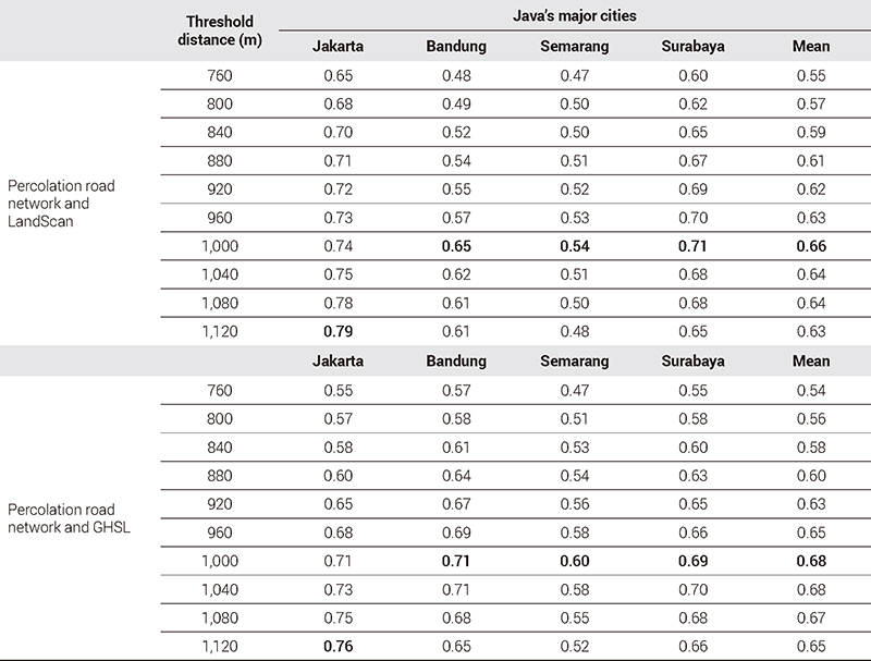
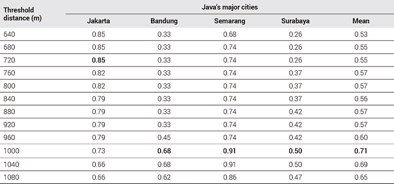
Inspired by Ou et al. (2023), we adapted their methodology for Java, adjusting the distance threshold to account for differences in road network density. To evaluate model accuracy, we compared percolation clusters with population density and built-up area data for the largest clusters using the Jaccard index. Testing various thresholds, we found that the highest similarity occurred at 1,000 meters (see <Table 4>). The mean Jaccard index for four major urban clusters in Java reached 0.66 when comparing LandScan data with percolation road networks, and 0.68 when comparing percolation networks with GHSL data. These results suggest that the spatial distribution of urban areas derived from percolation aligns well with other data sources. This comparison result shows how road connectivity and accessibility relate to geographic and socio-economic factors. <Table 4> presents the overlap results between percolated road networks, LandScan population data, and GHSL data at different thresholds.
Jaccard index comparison against satellite-based delineation
Using a 1,000-meter threshold for road network connectivity, our analysis identifies eight major clusters across Java: Jakarta, Bandung, Surabaya, Semarang, Yogyakarta, Surakarta, Cirebon, and Malang (Figure 4). These clusters include both large cities and their surrounding interconnected urban clusters, providing a comprehensive view of Java’s densely populated areas. The results align well with existing urban data, confirming the effectiveness of this approach in delineating urban areas and supporting findings from previous studies (Cao et al., 2020; Henderson et al., 2021).

Comparison of percolation cluster with satellite-based urban delineation
3. Comparison with Flow-based Delineation
To evaluate our model’s performance against traditional approaches, we compared our percolation-based urban clusters map of Java with those derived from flow-based methods in previous studies (Day and Ellis, 2014; Bosker et al., 2021). We projected our percolation results onto Indonesia’s city/district administrative boundaries and compared them with commuting flow data-based delineations (see <Figure 5>).

Comparison of percolation cluster with flow-based delineation map
Overall, the average Jaccard index for the four main urban clusters in Java identified a peak at the 1000 m threshold (0.71), indicating an overall similarity of 71% at this level of connectivity (Table 5). While for all identified major clusters, the average Jaccard index comparing our results with each reference map ranged from 0.51 compared to Bosker et al. (2021) and 0.56 compared to Day and Ellis (2014). This indicates that road network density effectively represents inter-city commuting patterns and captures the economic extent of large cities. Thus, the percolation-based approach is a suitable alternative for delineating urban clusters, demonstrating a fair level of agreement with traditional flow-based methods.
Jaccard index comparison against flow-based delineation
Nevertheless, it is crucial to acknowledge that the two reference maps produce differing estimation outcomes due to variations in data sources, methodologies, and time frames. These discrepancies highlight the inherent challenges in delineating urban clusters, particularly in countries like Indonesia where official definitions of urban clusters boundaries are lacking. The absence of standardized boundaries complicates the definitive determination of which map offers a more accurate estimation.
Given these challenges, our assessment emphasizes the similarity between the results obtained from road network percolation and those derived from commuter data approaches. The moderate Jaccard indices indicate a significant overlap in the identified urban clusters, supporting the validity of road network percolation as a method for delineating urban areas. This overlap aligns well with traditional methods based on commuting data and suggests that road network density in large urban clusters effectively represents inter-city commuting patterns and captures the economic extent of cities. Therefore, a percolation-based approach proves to be a suitable alternative for urban clusters delineation.
4. Potential Changes in the Urban Clusters of Java Island
The analysis of percolation results based on road network data from 2009 to 2023 highlights the significant impact of road network expansion on urban clusters in Java. This suggests that future road construction or expansion could further influence these patterns. The General Plan for the National Road Network (2020-2040) reflects the government's commitment to expanding Java's road network. While the percolation model can predict potential future urban clusters based on planned road networks, actual development remains uncertain due to various factors.
Kalpana et al. (2021) emphasize that using existing road network datasets can help forecast urban clusters under various scenarios. In this study, traditional percolation theory is adapted by gradually increasing the threshold distance to analyze potential changes in urban clusters, assuming a business-as-usual scenario (Stauffer and Aharony, 1994; Kalpana et al., 2021). Threshold levels were expanded up to 2000 meters (see <Figure 6>), revealing significant changes in urban clusters. For instance, the merging of Jakarta with Bandung and the convergence of Surabaya-Malang with neighboring cities suggest the emergence of potential future urban clusters.

Potential changes of urban clusters in Java Island
These findings underscore the importance of proactive urban planning to manage anticipated growth and the integration of metropolitan areas. As urban areas expand beyond current administrative boundaries, a coordinated approach to regional development becomes essential. Such an approach will address the challenges and opportunities of large-scale urbanization, ensuring sustainable growth and an improved quality of life for residents across Java.
In Indonesia, the phenomenon of development following road construction is evident across various sectors and regions, leading to the expansion of the road network, which in turn facilitates urban cluster integration and influences the growth of urban clusters. This underscores the value of theoretical frameworks for understanding urban spatial dynamics and highlights the necessity for informed decision-making in infrastructure investments and urban planning. Such decisions are crucial for promoting balanced development and enhancing regional connectivity. A major challenge in city and regional planning is managing these urban clusters, which span multiple jurisdictions and governing bodies. To address this challenge, the government plans to establish a Jakarta Agglomeration Zone Council under the Jakarta Special Region Bill (DKJ). This council will oversee development in Jakarta and its surrounding areas, aiming to enhance cross-sectoral and regional cooperation and address the complex issues of planning and implementing sustainable development. Accurately defining urban clusters boundaries is essential for understanding the developmental relationships between cities, guiding regional functions, and formulating effective management policies.
Another key finding from the percolation analysis is its insight into the growth of smaller urban centers in districts such as Madiun, Kediri, and Purwakarta. The model effectively captures the expansion of these smaller cities, reflecting urbanization dynamics at multiple scales. This observation aligns with Wirawan and Tambunan (2018) and Mardiansjah (2020), which highlight the significant growth of small and medium-sized cities across Java. Urban expansion involves not just outward growth but also strengthening peripheral areas relative to larger centers. Improved road networks enhance connectivity and accessibility, stimulating economic activity and drawing populations to previously peripheral areas. This infrastructure upgrade integrates smaller towns with larger cities, transforming them into small urban hubs and contributing to a more balanced urban network. This highlights the role of infrastructure projects in promoting growth in less-developed areas. These insights can guide policymakers and urban planners in infrastructure investment and regional development strategies, improving our understanding of Indonesia's urbanization process.
V. Conclusions
This paper aims to identify urban clusters in Java using percolation analysis of road networks. It explores how the expansion of Java's road network from 2009 to 2023 has influenced urban growth and clusters. The percolation model, using a 1,000-meter threshold, closely matches population density and built-up area data, with average Jaccard indices of 0.66 when compared to LandScan data and 0.68 compared to GHSL data. These results demonstrate the model's effectiveness in capturing the extent of urban areas in Java's major cities. Furthermore, comparisons with previous urban cluster maps show favorable Jaccard indices of 0.56 and 0.51, suggesting that the road network percolation model is a valid alternative to traditional commuting flow-based methods.
The research contributes by identifying urban clusters independent of administrative boundaries using percolated road networks. Dense road networks typically indicate higher concentrations of urban development, revealing the true size of urban areas. This approach highlights the limitations of relying solely on administrative boundaries, which often fail to accurately reflect the spatial extent of urbanization. The percolation model offers a powerful tool for urban planning and infrastructure development, with potential for predicting future urban clusters. Understanding how road infrastructure impacts urban growth allows for better planning and more interconnected cities.
Our findings emphasize the need for urban planning strategies that go beyond administrative borders, integrating spatial policies that consider the effects of road infrastructure on urban clusters. Percolation models offer a versatile approach applicable across various regions, providing valuable insights into urban clusters and their development. Future research should consider additional factors beyond road networks, such as other relevant data and aspects of urban infrastructure, to improve the model's predictive accuracy and deepen the understanding of urban clusters.
Acknowledgments
This work was supported by the Ministry of Education of the Republic of Korea and the National Research Foundation of Korea (NRF-2021S1A3A2A01087370).
References
-
Akin, D. and Ocalir, E.V., 2022. “Delineating Functional Regions as New Strategic and Spatial Planning Clusters and Identifying Megaregions Based on Intercity Freight Flows and a Composite Economic Index: Case of Turkey”, Journal of Urban Planning and Development, 148(4).
[https://doi.org/10.1061/(ASCE)UP.1943-5444.0000871]

-
Arcaute, E., Molinero, C., Hatna, E., Murcio, R., Vargas-Ruiz, C., Masucci, A.P., and Batty, M., 2016. “Cities and regions in Britain through Hierarchical Percolation”, Royal Society Open Science, 3: 150691.
[https://doi.org/10.1098/rsos.150691]
-
Bitner, A., Hołyst, R., and Fiałkowski, M., 2009. “From Complex Structures to Complex Processes: Percolation Theory Applied to the Formation of a City”, Physical Review E - Statistical, Nonlinear, and Soft Matter Physics, 80(3 Pt 2): 037102.
[https://doi.org/10.1103/PhysRevE.80.049902]
-
Bosker, M., Park, J., and Roberts, M., 2021. “Definition Matters. Metropolitan Areas and Agglomeration Economies in a Large-developing Country”, Journal of Urban Economics, 125: 103275.
[https://doi.org/10.1016/j.jue.2020.103275]
-
Buchori, I., Sugiri, A., Maryono, M., Pramitasari, A., and Pamungkas, I.T.D., 2017. “Theorizing Spatial Dynamics of Metropolitan Regions: A Preliminary Study in Java and Madura Islands, Indonesia”, Sustainable Cities and Society, 35: 468-482.
[https://doi.org/10.1016/j.scs.2017.08.022]
-
Burger, M. and Meijers, E., 2012. “Form follows function? Linking Morphological and Functional Polycentricity”, Urban Studies, 49(5): 1127-1149.
[https://doi.org/10.1177/0042098011407095]
-
Cao, W., Dong, L., Wu, L., and Liu, Y., 2020. “Quantifying Urban Areas with Multi-source Data based on Percolation Theory”, Remote Sensing of Environment, 241: 111730.
[https://doi.org/10.1016/j.rse.2020.111730]
-
Chen, L., Yu, L., Yin, J., and Xi, M., 2023. “Impact of Population Density on Spatial Differences in the Economic Growth of Urban Agglomerations: The Case of Guanzhong Plain Urban Agglomeration, China”, Sustainability, 15(19): 14601.
[https://doi.org/10.3390/su151914601]
-
Chen, Z. and Yeh, A.G.O., 2022. “Delineating Functional Urban Areas in Chinese Mega City Regions Using Fine-grained Population Data and Cellphone Location Data: A Case of Pearl River Delta”, Computers, Environment and Urban Systems, 93: 101771.
[https://doi.org/10.1016/j.compenvurbsys.2022.101771]
-
Day, J. and Ellis, P., 2014. “Urbanization for Everyone: Benefits of Urbanization in Indonesia’s Rural Regions”, Journal of Urban Planning and Development, 140(3): 04014006.
[https://doi.org/10.1061/(ASCE)UP.1943-5444.0000164]
-
Dingel, J.I., Miscio, A., and Davis, D.R., 2021. “Cities, Lights, and Skills in Developing Economies”, Journal of Urban Economics, 125: 103174.
[https://doi.org/10.1016/j.jue.2019.05.005]
-
Duranton, G., 2015a. “A Proposal to Delineate Metropolitan Areas in Colombia”, Desarrollo y Sociedad, 2015(75): 223-264.
[https://doi.org/10.13043/dys.75.6]
-
Duranton, G., 2015b. “Delineating Metropolitan Areas: Measuring Spatial Labour Market Networks through Commuting Patterns”, in Advances in Japanese Business and Economics edited by Watanabe, T., Uesugi, I., and Ono, A., 107-133. Berlin: Springer.
[https://doi.org/10.1007/978-4-431-55390-8_6]
-
Firman, T., 2009. “The Continuity and Change in Mega-urbanization in Indonesia: A Survey of Jakarta-Bandung Region (JBR) Development”, Habitat International, 33(4): 327-339.
[https://doi.org/10.1016/j.habitatint.2008.08.005]
-
Firman, T., 2017. “The Urbanisation of Java, 2000-2010: Towards ‘the Island of Mega-urban Regions’”, Asian Population Studies, 13(1): 50–66.
[https://doi.org/10.1080/17441730.2016.1247587]
-
Firman, T. and Dharmapatni, I.A.I., 1995. “The Emergence of Extended Metropolitan Regions in Indonesia: Jabotabek and Bandung Metropolitan Area”, Review of Urban & Regional Development Studies, 7(2): 167-188.
[https://doi.org/10.1111/j.1467-940X.1995.tb00069.x]
- Freeman, A., 2004. Measuring and Comparing World Cities, Germany: University Library of Munich.
-
Fu, W., Luo, C., and He, S., 2022. “Does Urban Agglomeration Promote the Development of Cities? An Empirical Analysis Based on Spatial Econometrics”, Sustainability, 14(21): 14512.
[https://doi.org/10.3390/su142114512]
- Gao, X., Xu, Z., and Niu, F., 2015. “Delineating the Scope of Urban Agglomerations based upon the Pole-Axis Theory”, Progress in Geography, 34(3): 280-289.
-
Grimmett, G., 1999. “What is Percolation?” in Percolation, 1–31. Berlin: Springer.
[https://doi.org/10.1007/978-3-662-03981-6_1]
-
Handayani, W. and Rudiarto, I., 2014. “Dynamics of Urban Growth in Semarang Metropolitan – Central Java: An Examination Based on Built-Up Area and Population Change”, Journal of Geography and Geology, 6(4): 80-87.
[https://doi.org/10.5539/jgg.v6n4p80]
-
He, X., Yuan, X., Zhang, D., Zhang, R., Li, M., and Zhou, C., 2021. “Delineation of Urban Agglomeration Boundary Based on Multisource Big Data Fusion - A Case Study of Guangdong - Hong Kong - Macao Greater Bay Area (GBA)”, Remote Sensing, 13(9): 1801.
[https://doi.org/10.3390/rs13091801]
-
Henderson, J.V., Nigmatulina, D., and Kriticos, S., 2021. “Measuring Urban Economic Density” Journal of Urban Economics, 125: 103188.
[https://doi.org/10.1016/j.jue.2019.103188]
-
Huynh, H.N., Makarov, E., Legara, E.F., Monterola, C., and Chew, L.Y., 2018. “Characterisation and Comparison of Spatial Patterns in Urban Systems: A Case Study of U.S. Cities” Journal of Computational Science, 24: 34-43.
[https://doi.org/10.1016/j.jocs.2017.12.001]
- Huynh, H.N. and Ramli, M.A.B., 2022. Urban Landscape from the Structure of Road Network: A Complexity Perspective. https://arxiv.org/abs/2201.10949v1
-
Kalpana, L.D.C.H.N., Abenayake, C., Jayasinghe, A., Mahanama, P.K.S., and Sanjaya, N., 2021. “A Novel Approach to Measure the Pattern of Urban Agglomeration based on the Road Network”, International Journal of Sustainable Development and Planning, 16(2): 251-262.
[https://doi.org/10.18280/ijsdp.160205]
-
Katherina, L.K. and Indraprahasta, G.S., 2019. “Urbanization Pattern in Indonesia’s Secondary Cities: Greater Surabaya and Its Path toward a Megacity. IOP Conference Series”, Earth and Environmental Science, 338(1): 012018.
[https://doi.org/10.1088/1755-1315/338/1/012018]
-
Kuncoro, M. and Wahyuni, S., 2009. “FDI Impacts On Industrial Agglomeration: The Case Of Java, Indonesia”, Journal of Asia Business Studies, 3(2): 65-77.
[https://doi.org/10.1108/15587890980000412]
-
Li, M., Liu, R.R., Lü, L., Hu, M.B., Xu, S., and Zhang, Y.C., 2021. “Percolation on Complex Networks: Theory and Application” Physics Reports, 907: 1-68.
[https://doi.org/10.1016/j.physrep.2020.12.003]
-
Liang, J., Li, F., and Mao, L., 2010. “Review of the Methods of Delimitation for the Spatial Scope of Urban Agglomeration”, Paper presented at the 18th International Conference on Geoinformatics, Beijing.
[https://doi.org/10.1109/GEOINFORMATICS.2010.5567776]
-
Liao, Z. and Zhang, L., 2023. “Spatio-temporal Evolution and Future Simulation of Urban Agglomeration Expansion in the Guangdong–Hongkong–Macau Greater Bay Area”, Humanities and Social Sciences Communications, 10: 468.
[https://doi.org/10.1057/s41599-023-01968-5]
-
Makse, H.A., Andrade, J.S., Batty, M., Havlin, S., and Stanley, H.E., 1998. “Modeling Urban Growth Patterns with Correlated Percolation”, Physical Review E, 58(6): 7054-7062.
[https://doi.org/10.1103/PhysRevE.58.7054]
-
Mardiansjah, F.H., 2020. “Extended Urbanization in Small-ersized Cities and Small Town Development in Java: The Case of the Tegal Region”, IOP Conference Series: Earth and Environmental Science, 447(1): 012030.
[https://doi.org/10.1088/1755-1315/447/1/012030]
-
Mardiansjah, F.H., Rahayu, P., and Rukmana, D., 2021. “New Patterns of Urbanization in Indonesia: Emergence of Non-statutory Towns and New Extended Urban Regions”, Environment and Urbanization ASIA, 12(1): 11-26.
[https://doi.org/10.1177/0975425321990384]
-
Octifanny, Y. and Hudalah, D., 2017. “Urban Agglomeration and Extension in Northern Coast of West Java: A Transformation into Mega Region”, IOP Conference Series: Earth and Environmental Science, 79(1): 012011.
[https://doi.org/10.1088/1755-1315/79/1/012011]
-
Ou, Y., Kim, E., Liu, X., and Nam, K.M., 2023. “Delineating Functional Regions from Road Networks: The Case of South Korea”, Environment and Planning B, 50(6): 1677-1694.
[https://doi.org/10.1177/23998083231172198]
-
Pan, H., Cong, C., Zhang, X., and Zhang, Y., 2020. “How Do High-speed Rail Projects Affect the Agglomeration in Cities and Regions?”, Transportation Research Part D: Transport and Environment, 88: 102561.
[https://doi.org/10.1016/j.trd.2020.102561]
-
Pravitasari, A.E., Indraprahasta, G.S., Rustiadi, E., Rosandi, V.B., Stanny, Y.A., Wulandari, S., Priatama, R.A., and Murtadho, A., 2024. “Dynamics and Predictions of Urban Expansion in Java, Indonesia : Continuity and Change in Mega-Urbanization”, International Journal of Geo-Information, 13(3): 102.
[https://doi.org/10.3390/ijgi13030102]
-
Rasmussen, L.V., Mertz, O., Christensen, A.E., Danielsen, F., Dawson, N., and Xaydongvanh, P., 2016. “A Combination of Methods Needed to Assess the Actual Use of Provisioning Ecosystem Services”, Ecosystem Services, 17: 75-86.
[https://doi.org/10.1016/j.ecoser.2015.11.005]
-
Rosenthal, S.S. and Strange, W.C., 2004. “Evidence on the Nature and Sources of Agglomeration Economies”, Handbook of Regional and Urban Economics, 4: 2119-2171.
[https://doi.org/10.1016/S1574-0080(04)80006-3]
- Rustiadi, E. and Panuju, D.R., 2002. “Spatial Pattern of Suburbanization and Land-Use Change Process: Case Study in Jakarta Suburb” in Land Use Changes in Comparative Perspective edited by Himiyama, Y., Hwang, M., and Ichinose, T., 33-52.
-
Rustiadi, E., Pravitasari, A.E., Setiawan, Y., Mulya, S.P., Pribadi, D.O., and Tsutsumida, N., 2021. “Impact of Continuous Jakarta Megacity Urban Expansion on the Formation of the Jakarta-Bandung Conurbation over the Rice Farm Regions”, Cities, 111: 103000.
[https://doi.org/10.1016/j.cities.2020.103000]
- Saleh, M.I., 2014. “Delineation of Functional Urban Areas and Evidence of Agglomeration Economies in Indonesia”, Ph.D. Dissertation, National Graduate Institute for Policy Studies.
- Samad, T., 2012. “Indonesia’s Urban Development Towards Inclusive and Sustainable Economic Growth”, In Kebijakan dan Implemantasinya: Setahun Pelaksanaan MP3EI.
-
Setyono, J.S., Yunus, H.S., and Giyarsih, S.R., 2016. “The Spatial Pattern of Urbanization and Small Cities Development in Central Java: A Case Study of Semarang-Yogyakarta-Surakarta Region”, Geoplanning: Journal of Geomatics and Planning, 3(1): 53-66.
[https://doi.org/10.14710/geoplanning.3.1.53-66]
- Simatupang, W., 2008. “Conurbations in Java, Indonesia”, Paper presented at the 44th ISOCARP Congress, Dalian.
-
Skadins, T., Krumins, J., and Berzins, M., 2019. “Delineation of the Boundary of an Urban Agglomeration: Evidence from Riga, Latvia”, Urban Development Issues, 62(1): 39-46.
[https://doi.org/10.2478/udi-2019-0007]
- Stauffer, D. and Aharony, A., 1994. Introduction to Percolation Theory (2nd ed.). London: Taylor & Francis.
-
Tapia-Mcclung, R., Montejano-Escamilla, J.A., and Caudillo-Cos, C.A., 2023. “Defining City Boundaries through Percolation Theory: The Case of the Mexican Urban System”, Economia, Sociedad y Territorio, 23(73): 753-778.
[https://doi.org/10.22136/est20232087]
-
Wibowo, Y.N.A. and Kudo, T., 2019. “Agglomeration and Urban Manufacture Labor Productivity in Indonesia”, Signifikan: Jurnal Ilmu Ekonomi, 8(2): 145-158.
[https://doi.org/10.15408/sjie.v8i2.9316]
-
Wirawan, B. and Tambunan, J.R., 2018. “Challenges on Java’s Small City Spatial Planning”, IOP Conference Series: Earth and Environmental Science, 158(1): 012054.
[https://doi.org/10.1088/1755-1315/158/1/012054]
-
Wirth, L., 1938. “Urbanism as a Way of Life”, American Journal of Sociology, 44(1): 1–24.
[https://doi.org/10.1086/217913]
-
Xie, Z., Yuan, M., Zhang, F., Chen, M., Tian, M., Sun, L., Su, G., and Liu, R., 2023. “A Structure Identification Method for Urban Agglomeration Based on Nighttime Light Data and Railway Data”, Remote Sensing, 15(1): 216.
[https://doi.org/10.3390/rs15010216]
-
Yu, J., Meng, Y., Zhou, S., Zeng, H., Li, M., Chen, Z., and Nie, Y., 2023. “Research on Spatial Delineation Method of Urban-Rural Fringe Combining POI and Nighttime Light Data-Taking Wuhan City as an Example”, International Journal of Environmental Research and Public Health, 20(5): 4395.
[https://doi.org/10.3390/ijerph20054395]