Development of an Index for Diagnosing Regional Inequality Levels and Analysis of Characteristics by Region
Abstract
In South Korea, emphasizing efficiency over equity in urban development strategies has led to a sustained concentration within the capital region, perpetuating regional disparities. Regarding inequality, the deepening inter-regional disparities, coupled with the deprivation of opportunities, are questioning the feasibility of a balanced development. This study utilizes a multiple deprivation index to analyze spatial patterns of inequality across 250 municipalities nationwide, aiming to diagnose regional imbalances. Therefore, 40 detailed indicators capable of measuring deprivation levels were collected. A rescaling process followed by reliability testing organized these indicators into six sector-specific categories. Subsequently, statistical significance was assessed through ANOVA and post-hoc tests. These findings were followed by conducting Global Moran’s I and LISA analyses. The analysis revealed that the degree of inequality by sector exhibits a consistent trend of spatial clustering, with notably high values in the living environment sector. However, when examining the overall level of inequality, the values diminish, displaying a generally uniform trend and indicating that inequality is not excessively concentrated in specific areas. This suggests the importance of considering the balance between sector-specific and overall inequality in developing future policies to reduce inequality.
Keywords:
Regional Disparity, Inequality, Multiple Deprivation Index, Spatial Autocorrelation, Spatial Pattern키워드:
지역 불균형, 불평등, 복합결핍 지수, 공간 자기 상관성, 공간 패턴Ⅰ. Introduction
1. Background and Purpose of Study
The growth and development of cities are significant because they offer opportunities for material abundance through economic growth and help ensure that the benefits of this growth are equally distributed within a society (Friedmann and Alonso, 1975; Rhee, 2004). In other words, continuous growth is possible when a city achieves both quantitative and qualitative development (Song and Yim, 2015). However, due to the trend in urban development that prioritizes efficiency over equity, equality between regions has gradually deteriorated, and furthermore, questions are being raised about balanced development in relation to the reduction in opportunities.
Regarding the issue of inequality in Korea, concentration in the capital region has not been alleviated with persisting regional imbalances. Considering the income distribution indicators as of 2021, the Gini coefficient has increased for both total and net assets since 2017, and the income quintile share ratio has also increased by a factor of 0.11 points compared to 2020, indicating that income inequality has become more severe. On the other hand, the income decile share ratio increased by a factor of 0.61 points compared to 2019, and the relative poverty rate decreased by 0.2% points compared to 2020, indicating that the income disparity has been alleviated (KOSIS, 2023). This is interpreted as a temporary phenomenon in which the median income and poverty line itself increased because the overall income increased during a specific period (COVID-19) due to disaster relief funds and subsidies for small businesses. The elderly poverty rate also decreased further in 2021 but is still the highest among the OECD countries. The national gross domestic product (GRDP) increased by 6.8% compared to 2020, but most of the production indicators are concentrated in Seoul and Gyeonggi, revealing the concentration in the capital region.
Furthermore, Korea is already experiencing serious aging of the population in rural regions. As of 2015, the aging rate in rural regions was 21.4%, which is higher than the national average (KOSIS, 2024a). This trend is gradually worsening, and as of 2022, the proportion of people aged 65 or older among the agricultural population reached 49.8%, which is almost half the total population (KOSIS, 2024a). Population migration along with aging is one of the main causes of inequality between regions. Currently, in Korea, overpopulation occurs in the capital region, which provides better residential conditions and job opportunities, while underpopulation continues in non-capital regions (Lee et al., 2023). As of 2022, the population of the capital region was calculated to be approximately 26.05 million or 50.5% of the national population (KOSIS, 2024b), which reflects the concentration of population in the capital region. With regard to the net migration to the capital region, young people in their 20s exhibited the highest outgoing rate. Population outflow changes the age structure within a region, promoting aging and accelerating the natural decline in birth rates, thereby resulting in a vicious cycle in regions with declining populations. In addition, due to industrial stagnation or sluggish local economy, there is a clear tendency for working-age populations in rural regions and small and medium-sized cities to move to large cities, and this phenomenon is further deteriorating regional imbalances in the country.
The deterioration of equality within cities has been identified as one of the factors that hinder balanced regional development. This situation can explain various problems and phenomena that occur in each field and has served as the basis for research that tracks the relationships (Jarman, 1984; Townsend et al., 1988; Carstairs and Morris, 1990; Son, 2002; Jeong et al., 2006). Accordingly, various indicators are being developed and utilized to measure the status of cities, such as a multidimensional poverty index, complex deprivation index, living social overhead capital (SOC) deprivation index, population decline index, urban decline index, urban resilience index, and park deprivation index (Lee et al., 2022; Shin et al., 2009; Im et al., 2021; Jo, 2014; Kim, 2019).
The inequality that the present study focuses on is the sustainability of regional coexistence. Because it values equity and inclusiveness, it is useful when seeking alternative qualitative urban development directions. Accordingly, this study analyzes the spatial patterns of inequality that appear at the regional level and seeks to diagnose regional imbalances. The specific purposes are as follows. First, we seek to identify patterns of regional inequality through regional deprivation indicators used to measure regional living conditions. In addition, we will derive regional differences in economy, society, health, safety, living environment, and inter-regional mobility. Second, the inequality that appears in the national space will be diagnosed using the multiple deprivation index, which is a composite of regional deprivation indices by sector, and then policy measures will be proposed to reduce these imbalances and disparities. These results may contribute to the establishment of spatial strategies for resolving imbalances, and directions for balanced regional development.
2. Scope and Method of Study
The spatial scope of the present study is 250 municipalities nationwide, and the smallest unit of analysis is Si·Gun·Gu. The temporal scope is one year in 2020 because the regions exhibiting inequality were analyzed using the latest available data in 2021. The content scope includes assessing the degree of inequality between regions based on the multiple deprivation index measurement indicator, verifying the spatial autocorrelation of the derived comprehensive inequality results, analyzing spatial patterns, and the like. Finally, this article presents a spatial strategy for balanced development in regions where inequality appears.
<Figure 1> shows the methodology of the present study. First, a total of 40 basic data applicable to local conditions were collected from theories and previous reports. The collected indicators reflect a total of six sectors in the analysis: economy, society, health, safety, living environment, and inter-regional mobility. Thereafter, an analysis of descriptive statistics (average score, standard deviation) of detailed indicators was conducted for the entire country, and statistical significance was tested through one-way analysis of variance (ANOVA) and Scheffe and Duncan post hoc tests (α=0.05). Based on the constructed data, clustering patterns were confirmed through the global Moran’s index to determine whether there was spatial autocorrelation in regions where inequality appeared. This is because the characteristics of a specific region where inequality appears tend to be similar for neighboring regions, so sectoral characteristics of inequality may be spatially clustered. Lastly, in order to analyze significant spatial correlations between regions, the spatial distribution of imbalance was visualized using the Local Indicators of Spatial Association (LISA) analysis technique.

Description of the research flow
Ⅱ. Review of Theories and Previous Studies
1. Review of Previous Studies on Inequality
Inequality does not have certain rules and manifests itself in diverse and heterogeneous ways in different regions (Smith, 2008). Inequality is a topic that is extensively studied in various academic fields including economics, sociology, and urbanology, and each field deals with inequality from its own perspective. In economics, it is explained that spatial differences between regions cause the concentration of economic activities in a specific region, which provides the region with favorable conditions and creates a spatial imbalance in economic performance (Combes et al., 2008). Sociology mainly deals with the unequal distribution of power, resources, and opportunities between individuals and groups, and explains that the unequal distribution is shown in various forms, including differences in accessibility to education, health, and housing, and differences in perceptions of cultural capital and identity. On the other hand, inequality in urbanology is discussed in relation to the uneven distribution of resources and services within an urban space. Inequality is approached from various aspects, including residential areas, education, health services, public spaces and infrastructure accessibility. Inequality commonly occurs in the process of urban and regional development, and represents geographical diversity and imbalance based on differences between regions. This kind of inequality is understood to have been continuous since the early stage formation of cities (Korzeniewicz and Moran, 2009).
In academic discussions on inequality, it is necessary to carefully consider the possible confusion with the concept of social exclusion. Although inequality and social exclusion are closely related to each other, there are clear differences in the approach and focus. Inequality primarily defines the uneven distribution of economic, social, and cultural resources and opportunities, which manifests itself as differences between individuals and groups. On the other hand, social exclusion includes not only economic exclusion but also exclusions in social networks and political participation, so it is a broader concept than inequality. The connection between the two above-mentioned concepts is based on the fact that deterioration of inequality increases the risk of social exclusion, and social exclusion may also further deteriorate inequality within specific groups. In addition, a clear distinction is required regarding the multidimensional aspects of inequality and social exclusion: the multidimensionality of inequality refers to inequalities that appear in several domains of life, while the multidimensionality of social exclusion focuses on the extensive exclusion processes and their dynamic characteristics that go beyond simple inequality (Levitas et al., 2007).
In previous studies conducted in Korea and other countries on inequality between regions based on these concepts, local deprivation has been measured at the socioeconomic level using residents’ income, education, employment, unemployment, health, living environment, crime, disability, and the like, based on a physical deprivation index, social deprivation index, and living environment index (Noble et al., 2006; Maier et al., 2012; Figari, 2012). In addition, studies have been conducted in Korea to measure regional disparities in terms of vulnerabilities in access to medical care, infrastructure, parks, and the like. Studies on inequality related to access to medical care include the study by Kim and Choi (2014), who developed a regional health deprivation index and then analyzed health inequality in urban areas, and the study by Shin et al. (2009), who developed an integrated deprivation index that matches the situation in Korea. In addition, Kim (2019) proposed a park deprivation index as an alternative indicator for promoting inclusive urban park policies applied the proposed index to seven major metropolitan cities, and presented a method for selecting regions with a relatively high demand for park policies. In relation to inclusion, Kang (2019) integrated underprivileged groups such as women, children, the elderly, and the disabled and then evaluated the inclusiveness of Busan Metropolitan City and derived a vulnerability map of areas with a low level of inclusion, thereby presenting spatial strategies for individual vulnerable areas. In addition, Kwon and Choi (2021) employed inclusion indicators to investigate the level of inclusiveness throughout the country to identify regions with high inclusiveness and regions with relatively low inclusiveness.
Among the previous studies, several are considered to be closely associated with the present study in the sense that available data was used on a pilot basis in those studies in an attempt to synthesize the granularity of spatial units and the degree of deprivation by areas. These include the study conducted by Jung et al. (2021), in which the current status of local living service facilities in Seoul was analyzed, and the degree of inequality in local living service facilities by autonomous district was measured, the study conducted by Lee and Nam (2021), in which a deficiency index was used to identify areas with a low level of smart city living services in Seoul, and the study conducted by Im (2021), which established the framework and indicator system of the multiple deprivation index to diagnose living SOC condition.
Next, studies that are highly associated with the present study, which employs indicators to derive spatial distribution patterns, were reviewed in each inequality section. The studies related to the economy sector are described below. Shin (2021) evaluated income disparity within metropolitan cities and provinces and between Si·Gun·Gu regions using household income big data and imbalance indices in 100 m-grid units, investigating and visualizing the global and local characteristics of the income distribution imbalance. Park and Lim (2016) analyzed the spatial patterns of poverty by measuring economic residential segregation using residential segregation indicators. In the society sector, Yoo and Choi (2019) measured the distribution of small business owners aggregated within a 100 m ×100 m grid through spatial autocorrelation, and visualized spatial dependence and heterogeneity for Cheonan-si and Asan-si. In addition, Choi et al. (2018) analyzed the disparities in labor productivity by autonomous district in the Honam region and assessed the spatial patterns and influences of the labor productivity disparity between regions, considering local spatial effects.
In the health sector, Kim et al. (2022) searched all of Korea to identify Si·Gun·Gu regions with high a stress recognition rate and Si·Gun·Gu regions with a low stress recognition rate and investigated their changes by performing a hot-stop analysis of stress recognition rates over the past 10 years from 2012 to 2021. Kim and Kim (2019) investigated the spatial distribution of health levels in Suwon-si and analyzed the degree of clustering of vulnerable groups with relatively good or poor health conditions. In the safety sector, Lee and Yeo (2021) analyzed the spatial distribution patterns of the integrated regional safety index for primary local governments throughout Korea and found that the capital region is a relatively safe area compared to other cities. Son et al. (2023) derived drought hot-spot areas by performing a spatial autocorrelation analysis on climate change scenarios, thereby predicting and analyzing the change patterns of future drought hot-spot areas in the Nakdong River basin.
In the living environment sector, Hong and Hong (2021) analyzed the degree of inequality in the location of electric vehicle charging stations using the bivariate local Moran’s index, and Kim (2016) analyzed the degree of inequality in opportunities to use public childcare services provided by Seoul Metropolitan Government.
2. Distinctiveness of the Present Study
Previous inequality-related studies have shown that various deprivation factors in social, cultural, spatial, and living environment categories converge into economic factors and thus affect the formation and reproduction of inequality. This perspective has limitations in that it may easily incline toward a material perspective since the formation and reproduction of inequality are ultimately determined by economic factors. Nevertheless, summarizing the details covered in previous studies, it can be seen that most studies employed socioeconomic indicators to measure the level of inequality and deprivation. In particular, regional disparities have been analyzed in terms of access to medical care and park distribution, and through this, inclusive policy measures have been proposed. This confirms that economic factors are relatively important from the perspective of inequality. However, some studies only focused on specific sectors, and a comprehensive analysis of inequality between regions as a whole is lacking. In addition, research directly addressing inequality between regions has been insufficient. Therefore, in addition to various socioeconomic indicators, there is a need to investigate the spatial inequality aspect of population migration between regions.
Therefore, the present study investigated how various patterns of inequality, including spatial inequality, are formed at the regional level in a situation where population outflow to the capital region is accelerating. In other words, the difference between the present study and previous studies is that the present study directly measured spatial inequality through movements between regions. In this regard, Chetty et al. (2014), Tammaru et al. (2016), and Lee and Shin (2018) showed that socioeconomic inequality can also occur in spatial forms between cities and regions. Therefore, most previous studies have employed the accessibility to living services and urban infrastructure among various dimensions of inequality, while the present study is unlike the previous studies in that it determined whether geographical factors cause spatial inequality.
Ⅲ. Analytical Framework
1. Selection of Multiple Deprivation Indicators to Measure Inequality
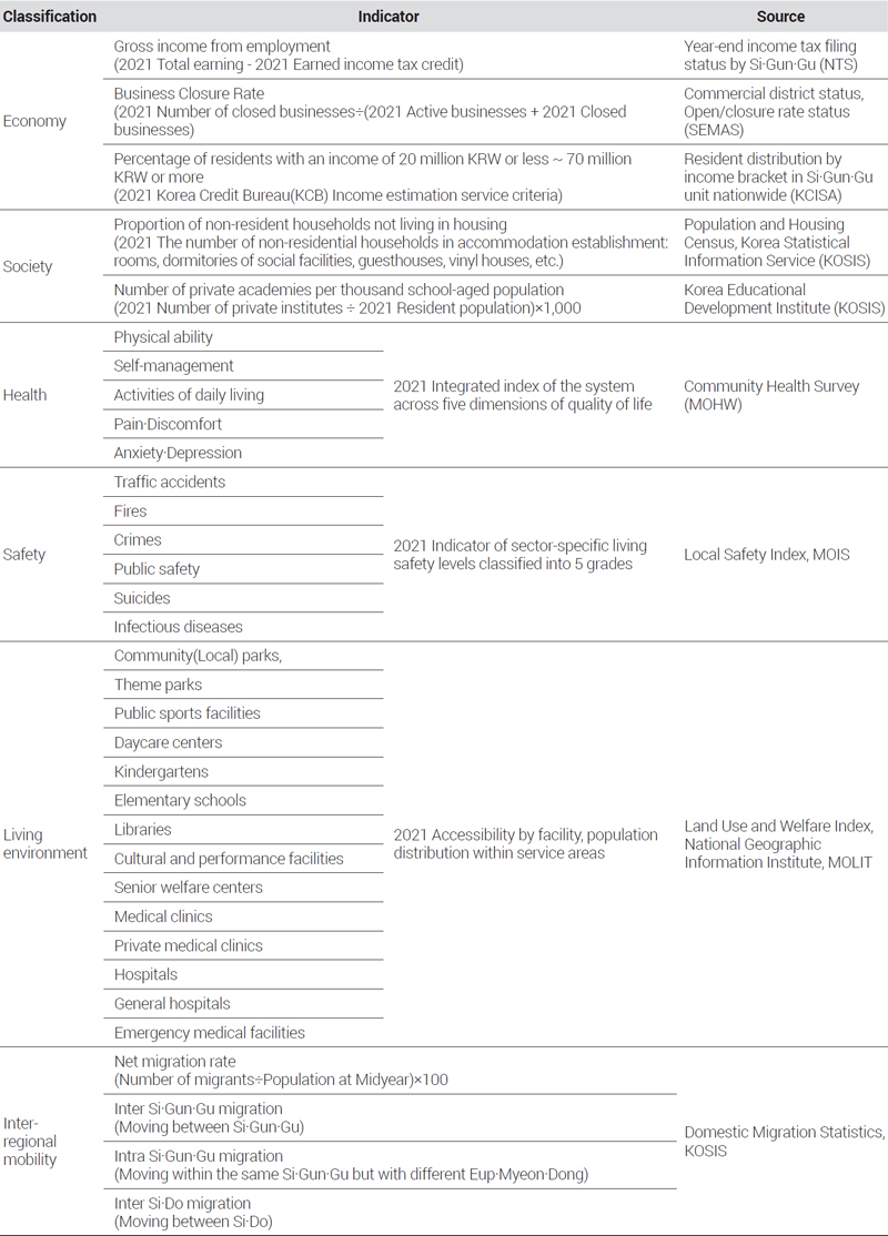
In the present study, in order to evaluate the level of inequality in the communities, we collected detailed indicators for each of the seven sectors of the Multiple Deprivation Index (MDI) used in Im et al. (2021). Thereafter, we further selected indicators suitable for measuring inequality based on the deprivation indicators proposed in various previous studies in Korea and other countries, as shown in <Figure 2>.

Selection and sectoral classification of inequality indicators
A total of 40 indicators were used to evaluate the level of inequality in individual regions, and they were established based on the data from the National Tax Service (NTS), Small and Medium Enterprises and Markets Service (SEMAS), Korea Culture and Information Service (KCISA), Korea National Statistics Portal (KOSIS), the Ministry of Health and Welfare (MOHW), the Ministry of Public Administration and Security (MOIS), and the Ministry of Land, Infrastructure and Transport (MOLIT) as of 2021. As shown in <Table 1>, the collected measurement indicators were divided into sectors of economy, society, health, safety, living environment, and inter-regional mobility according to the previous studies reviewed above.

Analysis indicators and source
First, for the economy sector, which includes income and employment, as indicators the study used gross income from employment, business closure rate, and the percentage of residents with an income of 20 million KRW to the percentage of residents with an income of 70 million KRW or more. For the society sector, which includes education and housing, the percentage of resident households not living in housing and the number of private academies per thousand school-aged population were used. For the health sector, the indicators from the Community Health Survey, data on physical ability, self-management, activities of daily living, pain and discomfort, and anxiety and depressive symptoms were used. For the safety sector, data on infectious diseases, traffic accidents, crimes, public safety, suicides and fires were used as indicators. For the living environment sector, the study used the population ratio within a basic living infrastructure service area, the population ratio within the community park service area, the population ratio within the theme park service area, the population ratio within the public sports facility service area, the infant population ratio within the daycare center service area, the infant population ratio within kindergarten service area, the population ratio within elementary school service area, the population ratio within library service area, the population ratio within cultural facility service area, the elderly population ratio within senior welfare center service area, the senior welfare center service area, the population ratio within medical clinic service area, the population ratio within private medical clinic service area, the population ratio within hospital service area, the population ratio within general hospital service area, and the population ratio within emergency medical facility service area were used. Lastly, for the inter-regional mobility sector, which includes geographical access and movement, the net migration rate, inter-Si·Gun·Gu migration rate, intra-Si·Gun·Gu migration rate, and the inter-Si·Do migration rate were used as indicators in the analysis.
In summary, the higher the business closure rate and the lower the gross income from employment and average monthly income in the economy sector, the higher the percentage of resident households not living in housing and the fewer the number of private academies in the society sector, the lower the Community Health Survey index in the health sector, the closer the safety grade to Grade 5 in the safety sector, the lower the population ratio within basic living infrastructure service area in the living environment sector, and the less the migration in the inter-regional mobility, the inequality was considered to be more severe in the region, compared to other regions. In particular, the low mobility rate in inter-regional mobility is directly related to the deterioration of inequality. This is a result of interactions due to the lack of economic opportunity, limited access to social resources, health and safety concerns, and insufficient basic living infrastructure, which limit the ability of individuals or families to migrate to other regions in pursuit of better living conditions. In addition, a low mobility rate itself can cause a deterioration of equality. This leads to an aging population along with an outflow of young people and the working-age population, thereby reducing social and economic activities in the region. These changes will further accelerate the stagnation of the local economy, and regions with low inter-regional mobility will remain with deteriorated comprehensive inequality compared to other regions, which can significantly reduce the development potential of the region. Therefore, regions with low population mobility can be interpreted to be the result of accumulated inequality in various sectors beyond simple population dynamics.
2. Analytical Method
The level of inequality was summarized using the collected indicators, using the process described below. In order to analyze the relative level of inequality between individual regions, a rescaling process was performed using Equation 1 to normalize the magnitude of the previously established indicators to the same unit. Calculations were performed for each indicator, and for consistent directionality, indicators whose larger values indicated more negative results were converted using the formula ‘1-(indicator value-minimum value)/(maximum value-minimum value).’
| (1) |
Afterwards, a reliability analysis was conducted to determine whether the 40 indicators had internal consistency, and a factor analysis was performed using Equation 2 to calculate weights. After multiplying the value converted by rescaling by the calculated weight, the deprivation index for each inequality sector was obtained, and the deprivation index for each sector was converted to a Z-score value, which is a standardized score, to obtain the final deprivation index.
| (2) |
Social phenomena that exhibit spatial characteristics are not distributed very evenly or randomly but mostly tend to follow a pattern. Spatial autocorrelation is a special property of spatial data in which location affects properties, and the closer geographically they are, the more similar the properties are. In this study, in the case of spatial weights, both contiguity and distance were used together to consider the impact of spatial distance while considering contiguity-based neighboring relationships. Accordingly, the Queen and Gaussian Kernel functions were used to examine the distribution in the six inequality sectors, and the Queen and Distance bands were used as spatial weights to investigate the clustering patterns of comprehensive inequality regions. First, the global Moran’s index, which is the most common method of measuring spatial autocorrelation, is a useful tool for analyzing whether the regional distribution pattern in the entire study area is clustered or random. The result value of the global Moran’s index ranges from -1 to 1: a value closer to –1 indicates stronger spatial dispersion, and a value closer to 1 indicates stronger spatial clustering. When the result value is close to 0 or is not statistically significant, it means that spatial correlation is absent (Lim and Park, 2017). The global Moran’s index is calculated using <Equation 3>.
| (3) |
In this way, the global Moran’s index measures the spatial autocorrelation of inequality indicators by sector across the entire regions. The index represents how uniformly inequality is distributed across the entire region or is distributed according to a specific pattern, and makes it possible to confirm whether inequality is spatially clustered. When the global Moran’s index has a statistically significant positive value, it means that inequality between regions is spatially clustered, indicating that inequality is concentrated in a specific region. Although this global Moran’s index is useful for identifying overall spatial correlation, it has clear limitations. The spatial autocorrelation index in regions whose unit region size is very large, or the spatial structure is not stable, has a high risk of causing errors in decisions regarding statistical inference and the validity of statistical models (Lee et al., 2015). The Local Indicators of Spatial Association (LISA) analysis technique is an analytical method capable of minimizing inferential errors in such statistical analysis methods and analyzing the spatial correlation structure at a local level (Anselin, 1995).
The local Moran’s index is a method that further localizes the scope of analysis of the Moran’s index, which determines the presence of autocorrelation in the entire space, and finds regions having different properties through individual comparisons, assuming that autocorrelation is present between a specific region and surrounding areas that are close to each other in terms of distance. The local Moran’s index is an approach for determining hot-spots through the ‘difference’between a specific area and surrounding areas, and it is calculated as in Equation 4. The local Moran’s index is a normalized value of the difference between and and can indicate similarity between regions through the magnitude of the index. A positive (+) value with a large absolute value means a hot-spot with similarity between regions, while a negative (-) value with a large absolute value indicates the absence of similarity between regions. Using the local Moran’s index, regions may be classified into four types based on the spatial correlation. Adjacent regions with high Moran’s index values are classified into HH (high-high), adjacent regions with low Moran’s index values into LL (low-low), and adjacent regions with high and low values into HL (high-low) or LH (low-high) (Chae al., 2014).
In other words, when regions with high index values are adjacent to each other, it means that they form a ‘hot-spot’ where regions with high inequality are gathered together. On the other hand, when regions with low index values are adjacent to each other, they represent ‘cold-spots’ where regions with relatively low inequality are adjacent to each other. When high and low regions are adjacent, they can be classified into ‘HL regions’ or ‘LH regions’ to identify regions exhibiting the spatial boundaries of inequality. Through this, regions with high and low inequality were examined on the map in a detailed manner, confirming how inequality is clustered regionally.
| (4) |
Ⅳ. Analytical Results
1. Characteristics of Regional Inequality
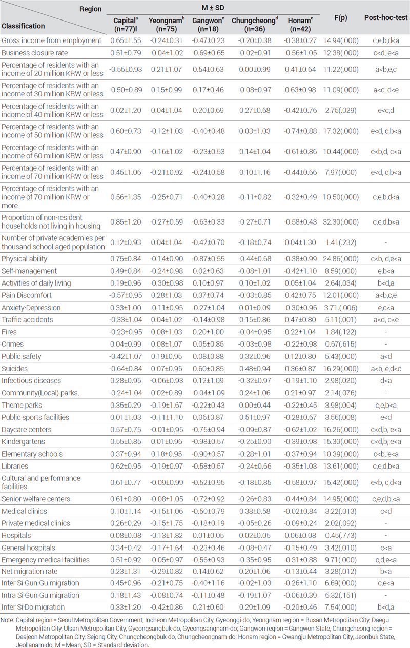
Before analyzing the spatial distribution and patterns in the degree of inequality by Si·Gun·Gu regions, we investigated the properties related to the detailed indicators in the five areas, as shown in <Table 2>. In this process, the Jeju region was excluded from the analysis because there were only two available samples (Jeju-si and Seogwipo-si), so the statistical reliability may be low in direct comparison with other regions.
Characteristics of regional inequality
As a result of the As shown in the results of the test, the nine detailed indicators of the economic sector exhibited statistically significant differences in all areas. It can be seen that the gross income from employment is higher in the capital region than in the Gangwon, Honam, Yeongnam, and Chungcheong areas, and the business closure rate is higher in the Chungcheong area than in the Gangwon area and higher in the Honam area than in the capital region. In terms of the percentage of residents at particular income levels, the percentages of residents with an income of 20 million KRW or less and 30 million KRW or less were lower in the capital region than in other areas, but the percentages of residents with an income of 50 million KRW or less, 60 million KRW or less, 70 million KRW or less, and 70 million KRW or more were the highest in the capital region, confirming that there is a clear economic disparity among the regions. Among the two detailed indicators in the society sector, the number of private academies per thousand school-aged population (p=0.232) did not show a significant difference among the areas. However, the percentage of resident households not living in housing was significantly lower in all other areas than in the capital region, showing that the housing problem in the capital region is more severe than in other regions.
Among the five detailed indicators of the health sector, the physical activity indicator was higher in the Yeongnam area than in the Gangwon area and higher in the capital region than in the Chungcheong and Homan areas. The self-management indicator was significantly lower in the Honam and Yeongnam areas than in the capital region, and the indicator of activities of daily living was significantly lower in the Yeongnam area than in the Chungcheong area and the capital region. The pain and discomfort indicator was lower in the capital region than in Yeongnam, Gangwon, and the Honam areas. In contrast, the anxiety and depression indicator was lower in the Honam and Gangwon areas than in the capital region. Based on the survey responses from the Community Health Survey, these results suggest that people who live in the capital region, where the population density is relatively higher compared to the other areas and the life structure requires the residents to be strict with themselves, may have exhibited a higher score in the physical body management compared to the average of the other areas. On the other hand, people who live in non-capital cities, where the population density is relatively lower compared to the capital region and the age of the residents is generally higher, may have exhibited higher scores in the indicators related to psychological and mental stability compared to the capital region, rather than in the indicators related to physical body management.
Among the six detailed indicators in the safety sector, no significant difference was found in the fire (p=0.122) and crime (p=0.615) indicators by area. The traffic accident indicator was higher in the Chungcheong area than in the capital region and higher in the Honam area than in the Gangwon area. The public safety indicator was significantly lower in the capital region than in the Chungcheong area. This result may be because the social and environmental problems caused by the high population density in the capital region had a negative impact on the indicator. The suicide indicator was higher in the Yeongnam area than in the capital region, and higher in the Gangwon area than in the Honam and Chungcheong areas. The infectious disease indicator was significantly lower in the Chungcheong area than in the capital region.
Among the 14 detailed indicators in the living environment sector, no significant difference was found by area in the community park (p=0.076), private medical clinics (p=0.092), and hospital accessibility indicators (p=0.773). The indicators of accessibility to theme parks, daycare centers, kindergartens, elementary schools, libraries, cultural and performance facilities, senior welfare centers, general hospitals, and emergency medical facilities were significantly lower in most of the areas than in the capital region. Excluding the capital region, the public sports facilities indicator was higher in the Honam area than in the Chungcheong area, the cultural and performance facilities indicator was higher in the Yeongnam area than in the Honam area, and the indicator for accessibility to hospitals was higher in the Chungcheong area than in the Gangwon area. In contrast to the capital region, the Gangwon area was found to be the area with the lowest accessibility to theme parks, daycare centers, kindergartens, elementary schools, libraries, cultural and performance facilities, senior welfare centers, hospitals, general hospitals, and emergency medical facilities.
Based on this, the imbalance in the distribution of public services and infrastructure by area can be confirmed. Among the four detailed indicators of inter-regional mobility, no significant difference by area was found in the intra-Si·Do (inter-Si·Gun·Gu) migration (p=0.151) indicator. The net migration rate indicator was significantly lower in the Yeongnam area than in the capital region, and the intra- Si·Do (intra-Si ·Gun·Gu) migration rate indicator was lower in the Gangwon and Honam areas than the capital region. The inter-Si·Do migration rate indicator was lower in the Yeongnam area than in the Chungcheong area and the capital region, confirming that there is a difference between geographically advantageous and disadvantageous areas. One of the main reasons for this result may be economic constraints and differences in realistic conditions. In particular, for people living in small and medium-sized cities outside the capital region, opportunities or possibilities for migration may be limited due to high living costs, moving costs including housing, and difficulties in obtaining stable jobs. These realistic constraints may make it difficult for many people to actually migrate even when they consider moving to another area where economic opportunities may be more. In other words, differences in inter-regional mobility can be interpreted as arising from conditions that make it difficult to participate in external socioeconomic processes.
2. Results of Autocorrelation and Spatial Pattern Analyses
In this study, we examined the presence and significance of spatial autocorrelation in areas where inequality appears for 250 Si·Gun·Gu regions throughout the country, as shown in <Table 3>. When defining spatial weights, we adopted an approach that considers the effects of both contiguity-based neighbor relationships and spatial distance. Through this approach, it was observed that inequality not only affects geographically adjacent regions but also allows the influence of distance to be considered as well. Accordingly, we examined not only the effect of inequality on regions that are geographically adjacent but also its effect depending on the distance. In this manner, we investigated the spatial distribution pattern of the level of inequality in different sectors to determine whether it occurs randomly or is concentrated in a specific space or region. Specifically, the Contiguity and Gaussian Kernel functions of Queen method were employed in combination to analyze the spatial patterns of regions where inequality is exhibited in each. The Queen method is often used to define relationships between adjacent regions, and the Gaussian Kernel function is useful for investigating a decrease in spatial influence depending on the distance. In addition, to analyze the clustering pattern of comprehensive inequality regions in more detail, the contiguity and distance bands of the Queen method were applied as spatial weights. This allowed us to derive patterns that reflect how the level of inequality in each region is affected by the physical distance from adjacent regions.
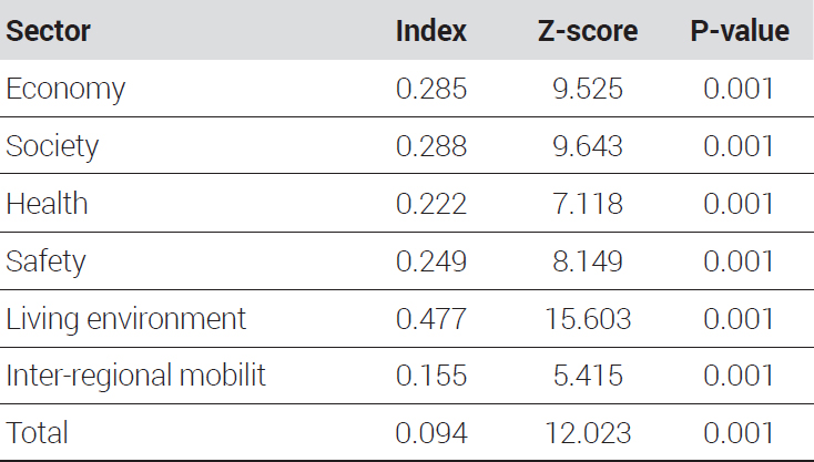
Analysis results of Global Moran’s I statistic
As a result of the analysis of the Global Moran’s I statistic, which was used to analyze the global spatial autocorrelation, the degree of regional inequality by sector exhibited a positive value at a significance (p-value) level of 0.01 in each of the sectors, indicating that a certain degree of spatial clustering is present in each sector. The value of the Global Moran’s I statistic derived from the economy sector was 0.285, and this value indicates that income levels, employment opportunities, and the like are similarly distributed among specific regions. In other words, the value means that regions with similar economic conditions tend to be spatially close to each other, and this can be interpreted to mean that economically active regions or, conversely, economically vulnerable regions are adjacent to each other. The value derived from the society sector was 0.288, indicating that the distribution of social factors such as education and housing are spatially clustered. Regions with similar social properties tend to be close to each other, which means that social resources and opportunities may differ in different regions.
The value derived from the health sector was 0.222. Although the indicators representing health status were clustered to some extent, it can be seen that the degree of clustering is weaker than that of other sectors. This means that the spatial distribution of the inequality in the health sector exhibits a less clear pattern compared to other sectors. The value derived from the safety sector was 0.249, which can be interpreted to mean that the safety-related indicators such as crime, public safety, and traffic accidents show a certain spatially clustered pattern. This means that certain regions may share a safe environment, or conversely, there may be regions where safety problems are concentrated. Among the six inequality sectors, the living environment sector showed the highest value of 0.477, which strongly indicates that accessibility within service areas such as parks and green spaces, cultural facilities, welfare facilities, and hospitals is clearly clustered among specific regions. The result may be interpreted to suggest that the inequality in the living environment sector shows a stronger tendency of spatial clustering compared to other sectors.
The value derived from the inter-regional mobility sector showed that the degree of spatial clustering was relatively low, which means that population mobility has a spatial clustering pattern that is relatively low compared to the level of inequality in other sectors. Lastly, the Global Moran’s I statistic for areas with comprehensive inequality, which was obtained by summing up the multiple deprivation indicators by sector, was 0.0094. Generally, this value indicates that there is no significant spatial clustering and shows an overall homogeneous trend. In other words, the overall level of inequality is very weak, but this may be because the relatively high degrees of spatial clustering found in the individual sectors have been offset in the overall sum. Therefore, the overall inequality is distributed in a relatively homogeneous manner across all regions, and this may be interpreted as a positive result since, although the inequality in each sector may be slightly different from the overall inequality level, the inequality is not overly concentrated in specific regions.
After testing the global spatial autocorrelation, a LISA analysis was performed to examine cluster-specific spatial distribution patterns in regions with deteriorated inequality among the 250 Si·Gun·Gu regions throughout the country. The results of the local spatial autocorrelation test according to the level of inequality by sector are shown in <Figure 3>.

Local spatial autocorrelation results by inequality sectors
First, with regard to the economy sector, 42 regions were classified into the HH type, characterized by a low degree of economic inequality compared to the adjacent regions, including Seocho-gu, Gangnam-gu, and Songpa-gu in Seoul, Ulsan Metropolitan City, Sejong-si, regions in Gyeonggi-do (Suwon-si, Seongnam-si, Anyang-si, Goyang-si, Yonginsi, etc.), Cheongju-si in Chungcheongbuk-do, Cheonan-si in Chungcheongnam-do, and Changwon-si in Gyeongsangnam-do. These regions with high income were located adjacent to each other. In addition, there were 38 LL-type regions characterized by a high degree of economic inequality compared to adjacent regions, including 11 Gu regions in Busan Metropolitan City and some Gun regions in Gangwon-do, Chungcheongbuk-do, Chungcheongnam-do, Jeonbuk State, Jeollanam-do, Gyeongbuk, and Gyeongsangnam-do, and these regions with low income were located adjacent to each other. Among spatially anomalous regions, there were 10 LH type regions where the degree of economic inequality in the adjacent region was high but the degree of economic inequality in the region was low: Gwangjin-gu, Seodaemun-gu, Dongjak-gu, Gwanak-gu in Seoul; Ganghwa-gun in Incheon Metropolital City; Paldal-gu in Suwon-si, Sujeong-gu in Seongnam-si, Sangnok-gu and Danwon-gu in Ansan-si in Gyeonggi-do; and Masanhappo-gu in Changwon-si in Gyeongsangnam-do. On the other hand, there were seven HL type regions where the degree of economic inequality in the adjacent region was low but the degree of economic inequality in the region was high: Gangseo-gu and Sasang-gu in Busan Metropolitan City; Deokjin-gu in Jeonju-si in Jeollabuk-do; Buk-gu in Pohang-si and Andong-si in Gyeongsangbuk-do; Jeju-si and Seogwipo-si in Jeju Special Self-Governing Province.
Second, with regard to the society sector, there were 32 HH type regions with a low level of social inequality compared to the adjacent regions, including Gwangju Metropolitan City and Ulsan Metropolitan City as well Cheongwon-gu in Cheongju-si in Chungcheongbuk-do; Jeonju-si in Jeollabuk-do; Naju-si in Jeollanam-do; Pohang-si in Gyeongsangbuk-do; Changwon-si and Yangsan-si in Gyeongsangnam-do, and these Si·Gun·Gu regions with good employment and education conditions were located adjacently. In addition, there were 28 LL type regions with a high level of social inequality compared to the adjacent regions, including 20 Gu regions in Seoul, 5 Gu regions in Incheon Metropolitan City, Uijeongbu-si, Bucheon-si, and Danwon-gu in Ansan-si in Gyeonggi-do, confirming that regions with severe disparities in education and employment were located adjacently. Among spatially anomalous regions, there were eight LH type regions where the degree of the society sector inequality in the adjacent region was high but the degree of the society sector inequality in the region was low: Sujeong-gu in Seongnam-si, Gyeonggi-do; Heungdeok-gu in Cheongju-si in Chungcheongbuk-do; Imsil-gun in Jeollabuk-do; Damyang-gun, Boseong-gun, Hampyeong-gun, and Jangseong-gun in Jeollanam-do; and Hadong-gun in Gyeongsangnam-do. In contrast, there were 11 HL-type regions where the degree of society sector inequality in the adjacent region was low but the degree of society sector inequality in the region was high: Yangcheon-gu, Seocho-gu, and Gangnam-gu in Seoul; Yeonsu-gu and Gyeyang-gu in Incheon Metropolitan City; and Manan-gu and Dongan-gu in Anyang-si, Gwangmyeong-si, Deogyang-gu in Goyang-si, Guri-si, and Namyangju-si in Gyeonggi-do.
Third, with regard to the health sector, there were 16 HH type regions with a low level of inequality in the health sector compared to adjacent regions, including the Gun regions in Chungcheongbuk-do, Jeollabuk-do, Jeollanam-do, Gyeongsangbuk-do, and Gyeongsangnam-do, and these regions were located adjacently. In addition, there were 39 LL type regions with a high level of inequality in the health sector compared to the adjacent regions, including 22 Gu regions in Seoul and Seo-gu in Incheon Metropolitan City; Nam-gu in Gwangju Metropolitan City, three Gu regions in Gyeonggi-do as well as nine Si regions and some areas in Changwon-si, indicating that these regions were located adjacent to large cities. Among spatially anomalous regions, there were 18 LH type regions where the degree of health sector inequality in the adjacent region was high but the degree of health sector inequality in the region was low, including Suseong-gu in Daegu Metropolitan City; Buyeo-gun in Jeollabuk-do; Yeongam-gun and Shinan-gun in Jeollanam-do; Andong-si, Gumi-si, and Mungyeong-si in Gyeongsangbuk-do; and Hamyang-gun in Gyeongsangnam-do. On the other hand, there were a total of 10 HL-type regions where the degree of the health sector inequality in the adjacent region was low but the degree of health sector inequality in the region was high: Dongdaemun-gu and Dongjak-gu in Seoul; Bupyeong-gu and Ganghwa-gun in Incheon Metropolitan City; and Seo-gu in Gwangju Metropolitan City, Sangnok-gu in Ansan-si, Deogyang-gu in Goyang-si, and Ilsandong-gu in Goyang-si, Namyangju-si, and Gwangju-si in Gyeonggi-do.
Fourth, with regard to the safety sector, there were 32 HH type regions with a low level of safety sector inequality compared to adjacent regions, including Songpa-gu in Seoul; Jung-gu, Dong-gu, and Ulju-gun in Ulsan Metropolitan City, 13 Gun regions in Gyeonggi-do; nine Si regions; Changwon-si and Haman-gun adjacent to Changwon-si in Gyeongsangnam-do, and these large cities and nearby regions with good safety conditions were located adjacently. In addition, there were 24 LL type regions with a high level of safety sector inequality compared to the adjacent regions, including Seongbuk-gu in Seoul; nine Gu regions in Busan Metropolitan City; Gangwon-do; Jeollabuk-do; Jeollanam-do; and Gyeongsangbuk-do, and these old city centers and Gun regions were located adjacently. Among spatially anomalous regions, there were six LH type regions where the level of safety sector inequality in the adjacent region was high but the level of safety inequality in the region was low: Gwanak-gu and Gangnam-gu in Seoul; Michuhol-gu in Incheon Metropolitan City; Nam-gu in Ulsan Metropolitan City; and Sangnok-gu and Danwon-gu in Ansan-si in Gyeonggi-do. On the other hand, there were 13 HL-type regions where the level of safety sector inequality in the adjacent region was low but the level of safety inequality in the region was high: Eunpyeong-gu in Seoul; Nam-gu, Buk-gu, and Haeundae-gu in Busan Metropolitan City; Yeongwol-gun in Gangwon-do; Yeongdong-gun in Chungcheongbuk-do; Gyeryong-si and Hongseong-gun in South Chungcheongnam-do; Yecheon-gun, Uljin-gun, and Ulleung-gun in Gyeongsangbuk-do; and Jeju-si and Seogwipo-si in Jeju Special Self-Governing Province.
Fifth, with regard to the living environment sector, there were 77 HH type regions with a low level of infrastructure accessibility inequality compared to the adjacent regions, including 25 Gu regions in Seoul, 15 regions in Busan Metropolitan City, 7 regions in Incheon Metropolitan City, Daejeon Metropolitan City, Ulsan Metropolitan City, and Gyeonggi-do, and these Si·Gun·Gu regions of the capital region and the metropolitan cities were located adjacently. In addition, there were 44 LL type regions with a high level of infrastructure accessibility inequality compared to the adjacent regions, including Icheon-si and Yeoju-si in Gyeonggi-do and 15 regions in Gangwon-do as well as Chungnam, Jeonbuk, Jeonnam, Gyeongbuk, Gyeongnam, and Jeju, and these regions distanced from the capital region were located adjacently. Among spatially anomalous regions, there were 8 LH type regions where the level of the infrastructure accessibility inequality in the adjacent region was high but the level of infrastructure accessibility inequality in the region was low: Gangseo-gu in Busan Metropolitan City; Jung-gu and Ganghwa-gun in Incheon Metropolitan City; Buk-gu in Ulsan Metropolitan City; and Namyangju-si, Siheung-si, Gimpo-si, and Gwangju-si in Gyeonggi-do. In contrast, there were a total of 8 HL type regions where the level of the infrastructure accessibility inequality in the adjacent region was low but the level of infrastructure accessibility inequality in the region was high: Chuncheon-si and Sokcho-si in Gangwon-do; Mokpo-si and Gwangyang-si in Jeollanam-do; Buk-gu in Pohang-si, Andong-si, and Gumi-si in Gyeongsangbuk-do; and Jinju-si in Gyeongsangnam-do.
Sixth, with regard to the inter-regional mobility sector, there were 7 HH type regions with a low level of mobility inequality compared to adjacent regions, including Jung-gu, Bupyeong-gu, Seo-gu, and Ganghwa-gun in Incheon Metropolitan City; 7 regions in Gyeonggi-do; Cheonan-si, Asan-si, and Dangjin-si in Chungcheongnam-do, and these regions where it is convenient to commute and move to the capital region or the nearby areas were located adjacently. In addition, there are 19 LL type regions with a high level of mobility inequality compared to the adjacent regions, including Jung-gu and Seo-gu in Busan Metropolitan City; 5 regions in Daegu Metropolitan City; and some Gun regions in Gangwon, Chungbuk, Jeonbuk, Gyeongbuk, and Gyeongnam, confirming that these regions have inconveniences in mobility due to the nature of mountainous or inland terrain. Among spatially anomalous regions, there were 3 LH type regions where the level of mobility inequality in the adjacent region was high but the level of mobility inequality in the region was low: Dong-gu and Ongjin-gun in the Incheon Metropolitan City; and Danwon-gu in Ansan-si in Gyeonggi-do. In contrast, there were a total of 4 HL type regions where the level of the mobility inequality in the adjacent region was low but the level of mobility inequality in the region was high: Dong-gu and Buk-gu in Daegu Metropolitan City; and Chuncheon-si and Wonju-si in Gangwon-do.
Regions forming the HH type spatial clusters, which are clusters of regions with a low level of inequality by sector, exhibited similar patterns in the sectors of economy, safety, living environment, and inter-regional mobility and similar patterns in the sectors of society and health. The former clusters were found in the capital region, including Seoul, Gyeonggi, and Incheon, and some regions of the Chungcheong area, but the latter clusters were found in the Jeolla and Gyeongsang areas. Regions forming the LL type spatial clusters, which are clusters of regions with a high level of inequality by sector, exhibited similar patterns only in the society and health sectors. This was the opposite of the HH type, which indicates that the concentration in the capital region actually causes suppression and deterioration of the indicators in the social or health-related sectors.
Lastly, <Figure 4> shows the results of the local spatial autocorrelation test with the regions with deteriorated comprehensive equality, which is a sum of the degree of multiple deprivation indices by sector. The results show that there were 80 HH type regions with a low level of equality compared to the adjacent regions, including 22 Gu regions in Seoul; 7 regions in Incheon Metropolitan City; Daejeon Metropolitan City; Sejong-Si; 31 regions in Gyeonggi-do; and some regions in Gangwon, Chungbuk, and Chungnam, and these regions near Seoul, Gyeonggi, and Incheon were located adjacently. In addition, there were 61 LL type regions with a high level of inequality compared to adjacent regions, including Jung-gu, Seo-gu, and Nam-gu in Daegu Metropolitan City as well as many Si·Gun·Gu regions in Gangwon, Jeonbuk, Jeonnam, Gyeongbuk, Gyeongnam, and Jeju, and these regions are located adjacently. Among spatially anomalous regions, there were 38 LH type regions where the level of inequality in the adjacent region was high but the level of mobility inequality in the region was low: Jongno-gu, Gangbuk-gu, and Seodaemun-gu in Seoul; Jung-gu, Ganghwa-gun, and Ongjin-gun in Incheon Metropolitan City; 11 regions in Gyeonggi-do; 8 regions in Gangwon-do; 4 regions in Chungbuk; and 9 regions in Chungnam. On the other hand, there were a total of 2 HL type regions where the level of inequality in the adjacent region was low but the level of mobility inequality in the region was high: 4 regions in Daegu Metropolitan City; 5 Gu regions in Gwangju Metropolitan City; 3 regions in Jeonbuk; 5 regions in Jeonam; 3 regions in Gyeongbuk; 5 regions in Gyeongnam; and Jeju-si in Jeju-do.

Comprehensive local spatial autocorrelation results across inequality sectors
Ⅴ. Conclusions
In this study, to consider the multidimensional nature of inequality, we established detailed deprivation indicators in the sectors of economy, society, health, safety, living environment, and inter-regional mobility, and created a multiple deprivation index that can diagnose and compare the level of inequality between municipalities. Based on this, we analyzed the spatial clustering patterns of the comprehensive level of inequality.
The analytical results can be summarized as follows. Except for the health sector, inequalities in all the sectors of economy, society, safety, living environment, and inter-regional mobility exhibited low levels of inequality in the centers of metropolitan cities and regions near metropolitan cities. This was clearly observed, particularly in the living environment sector, and it can be confirmed that inequality in this sector is clearly clustered between specific regions. Next, summarizing the results of the local spatial autocorrelation analysis, it can be seen that with regard to the level of inequality by sector across the country, regions with a high level of inequality are located near regions with a high level of inequality, and conversely, regions with a low level of inequality are located near regions with a low level of inequality, thereby forming spatial clusters. In addition, it was found that the level of inequality obtained by summing the deprivation indicators by sector showed little or very weak spatial autocorrelation, indicating a random distribution. Lastly, the results of the global spatial autocorrelation analysis showed that when the level of inequality in a region is lower than the average, the adjacent regions also have a low level of inequality to a certain extent, and when the degree of inequality in a region is higher than the average, the adjacent regions also have a high level of inequality. In addition, regions where the inequality level is high but the adjacent regions have a low level of inequality exhibited a trend of increasing inequality, while regions where the inequality level is low but the adjacent regions have a high level of inequality exhibited a trend of decreasing inequality. Based on these results, it can be confirmed that the clustering patterns by sector are different for different regions.
The spatial clustering of inequality described above provides important implications for establishing policy measures to solve the inequality issues between regions. According to the spatial autocorrelation analysis performed previously, regions with high inequality in living environment and economy sectors are likely to share similar disadvantages in income, job opportunities, and accessibility to public services, which suggests that intensive improvement is required in those regions. Therefore, measures such as strengthening direct income support for small and medium-sized local cities are necessary. This highlights the importance of time and efforts expended to increase regional understanding and achieve social changes, and continuous efforts and patience are required to resolve regional discrimination and inequality in this process, which involves complex social changes. Furthermore, it is important to assess inequality from a comprehensive perspective as well as with an individual analysis of inequality in each sector. In this way, it is possible to understand the effects of efforts to resolve inequality between regions. Future policy development and improvement measures should provide measures to resolve inequality in individual sectors as well as overall inequality. In summary, in the current situation where urban decline is accelerating, it is necessary to consider ways to resolve inequality among individual municipalities and promote coexistence between the capital region and non-capital regions.
The limitations of this study are as follows. First, an analysis using the raw values of an indicator corresponding to the proportion scale is more useful for quantification or using the average value, but the analysis was performed using the rank scale for the detailed indicators of the health sector and the detailed indicators of the safety sector. There were limitations in the data collection because the data from the Community Health Survey by the Korea Disease Control and Prevention Agency is survey data, and the regional safety index from the Ministry of the Interior and Safety is data in which only regional grades are published with the raw scores not disclosed. Second, a limitation when analyzing the current situation was that only the relative level of inequality was identified. The failure to clearly determine the degree of regional imbalance as an absolute value without a clear reference point is a part that requires improvement. Based on this, future research should be conducted as in-depth research to closely understand the deterioration patterns of regional inequality in a time-dependent manner. In order to understand the fundamental causes of the spatial patterns found in the present study, research should be conducted to derive causal relationships between various influencing factors.
The results of the present study have the following two implications. First, the results can help to facilitate evidence-based decision-making in order to reduce inequality in local communities through ongoing monitoring over time. Next, we attempted to gain a comprehensive understanding of inequality within the communities in relation to the imbalance between regions. This is significant in the sense that regions with a high need for inequality improvement were identified by deriving regions with comprehensive inequality by sector using the multiple deprivation index. In addition, based on this, it was confirmed that economic constraints and realistic conditions act as important factors for explaining differences in inter-regional mobility, especially mobility between the capital region and non-capital regions. This suggests that when establishing policies related to population movement, it is essential to comprehensively consider various factors such as providing financial support for migration, securing housing stability, and bridging economic disparities between regions, in addition to simple infrastructure improvement and creation of economic opportunities.
Acknowledgments
This study was supported by the 2023 Start-Up Fund of the Gyeongsang National University.
This study was partially supported by the 2023 National Research Fund of Korea (Grand number: 2023S1A5A8074659).
This article was prepared by supplementing and revising the presentation at the 2023 Spring Industry-University Conference of the Korea Planning Association.
References
-
Anselin, L., 1995, “Local indicators of spatial association-LISA”, Geographical Analysis, 27(2): 93-115.
[https://doi.org/10.1111/j.1538-4632.1995.tb00338.x]

- Carstairs, V. and Morris, R., 1990. Deprivation and Health in Scotland. Scotland: Aberdeen University Press.
-
Chae, J.E., Park, S.H., and Byun, B.S., 2014. “An Analysis of Spatial Concentrated Areas of Single Person Households and Concentrating Factors in Seoul”, Seoul Studies, 15(2): 1-16.
채정은·박소현·변병설, 2014. “서울시 1인 가구의 공간적 밀집 지역과 요인 분석”, 「서울도시연구」, 15(2): 1-16. -
Chetty, R., Hendren, N., Kline, P., and Saez, E., 2014. “Where Is the Land of Opportunity? The Geography of Intergenerational Mobility in the United States”, Quarterly Journal of Economics, 129(4): 1553-1623.
[https://doi.org/10.1093/qje/qju022]
-
Choi, S.H., Choi, M.S., and Kim, J.G., 2018. “Local Spatial Distribution and Causal Analysis of Labor Productivity Gap in Honam Region”, Journal of Korea Regional Economics, 16(3): 51-68.
[
https://doi.org/10.34282/krea.2018.16.3.3
]
최성환·최명섭·김재구, 2018. “호남권역 노동생산성 격차의 국지적 공간분포 및 원인 분석”, 「한국지역경제연구」, 16(3): 51-68. -
Combes, P., Mayer, T., and Thisse, J., 2008. Economic Geography: The Integration of Regions and Nations, Princeton: Princeton University Press.
[https://doi.org/10.2307/j.ctvcm4h9k]
-
Figari, F., 2012. “Cross-National Differences in Determinants of Multiple Deprivation in Europe”, The Journal of Economic Inequality, 10(3): 397–418.
[https://doi.org/10.1007/s10888-010-9157-9]
- Friedmann, J. and Alonso, W., 1975. Regional Policy; Readings in Theory and Applications, Massachusetts: The MIT Press.
-
Ha, S.J., Nam, K.C., Min, S.H., Jeon, S.J., and Park, J.S., 2014. Development A Study on the Examination and Application of the Regional Resilience for Sustainable Development, Gyeonggi: Korea Research Institute for Human Settlements.
하수정·남기찬·민성희·전성제·박종순, 2014. 「지속가능한발전을 위한 지역 회복력 진단과 활용 방안 연구」, 경기: 국토연구원. -
Hong, J.S. and Hong, S.J., 2021. “An Analysis of Spatial Equity of Electric Vehicle Charging Station”, Journal of the Architectural Institute of Korea, 37(12): 211-221.
홍진슬·홍성조, 2021. “전기차 충전소 입지의 공간적 형평성 분석”, 「대한건축학회논문집」, 37(12): 211-221. -
Im, E.S., Son, J.S., Lee, Y.J., Lee, B.K., Jang, Y.H., and Lee, K.J., 2021. Development and Utilization of Multiple Deprivation Index for Place-based Living Facilities Policy, Sejong: Korea Research Institute for Human Settlements.
임은선·손재선·이영주·이보경·장요한·이경주, 2021. 「지역 밀착형 생활 SOC 정책을 위한 복합결핍 지수개발 및 활용 방안」, 세종: 국토연구원. -
Jarman, B., 1984. “Underprivileged Areas: Validation and Distribution of Scores”, British Medical Journal (Clinical Research Ed.), 289(6458): 1587-1592.
[https://doi.org/10.1136/bmj.289.6458.1587]
-
Jeong, B.G., Jung, K.Y., Kim, J.Y., Moon, O.R., Lee, Y.H., Hong, Y.S., and Yoon, T.H., 2006. “The Relationship between Regional Material Deprivation and Standardized Mortality Ratio of the Community Residents Aged 15-64 in Korea”, Journal of Preventive Medicine and Public Health, 39(1): 46-52.
정백근·정갑열·김준연·문옥륜·이용환·홍영습·윤태호, 2006. “우리나라에서의 지역의 물질적 결핍 수준과 15-64세 인구 표준화 사망비의 관계”, 「예방의학회지」, 39(1): 46-52. -
Jo, Y.A., 2014. “A Study on Urban Decline Index”, Journal of Korea Planning Association, 49(7): 117-134.
[
https://doi.org/10.17208/jkpa.2014.11.49.7.117
]
조윤애, 2014. “도시쇠퇴 지수개발에 관한 연구”, 「국토계획」, 49(7): 117-134. -
Jung, D.E., Jung, K.J., and Yoo, S.Y., 2021. “Analyzing Inequality of Local Living Service Facilities in Seoul”, Journal of The Urban Design Institute of Korea Urban Design, 22(2): 59-78.
[
https://doi.org/10.38195/judik.2021.04.22.2.59
]
정다은·정광진·유석연, 2021. “서울시 지역생활서비스시설 불균등 분석”, 「한국도시설계학회 도시설계」, 22(2): 59-78. -
Kang, Y.W., Kim, J.G., and Shin, E.H., 2019. “Spatial Strategies of Inclusive Cities through Vulnerability Evaluation: Focused on Busan”, Journal of Civil and Environmental Engineering Research, 39(2): 281-286.
강윤원·김종구·신은호, 2019. “취약성 평가를 통한 포용 도시의 공간적 전략: 부산광역시를 대상으로”, 「대한토목학회논문집」, 39(2): 281-286. -
Kim, H.Y. and Choi, J.M., 2014. “Health Inequality of Local Area in Seoul: Reinterpretation of Neighborhood Deprivation”, Journal of The Korean Association of Regional Geographers, 20(2): 217-229.
김형용·최진무, 2014. “서울시 소지역 건강 불평등에 관한 연구: 지역 박탈에 대한 재해석”, 「한국지역지리학회지」, 20(2): 217-229. -
Kim, H.Y. and Kim, Y.J., 2019. “A Study on the Regional Difference of Obesity in the Social Vulnerabilities: Focused on the Suwon City”, Journal of the Korea Contents Association, 19(4): 682-689.
김한이·김용진, 2019. “사회취약계층 비만의 지역 격차에 관한 연구: 수원시를 중심으로”, 「한국콘텐츠학회 논문지」, 19(4): 682-689. -
Kim, K.S., 2016. “A Study on Spatial Equity of Opportunities to Use Public Childcare Services Focusing on National/Public Childcare Centers in Seoul”, Seoul Studies, 17(1): 45-64.
김규식, 2016. “공공 보육 서비스 이용 기회의 공간적 형평성 평가: 2009년과 2014년의 서울시 국공립어린이집을 대상으로” 「서울도시연구」, 17(1): 45-64. -
Kim, Y.E., Lee, H.W., and Park, J.H., 2022. “Analysis of Spatial Dependency and Hotspot of Stress Perception Rate at 243 District Levels in Korea”, The Journal of Humanities and Social Science 21, 13(5): 3877-3892.
[
https://doi.org/10.22143/HSS21.13.5.269
]
김예은·이희원·박종호, 2022. “최근 10년간 우리나라 시군구 단위 스트레스 인지율의 공간 의존성 변화 및 핫스팟 분석”, 「인문사회 21」, 13(5): 3877-3892. -
Kim, Y.G., 2019. “Development of Index of Park Deprivation to Promote Inclusive Living SOC Policy”, Journal of the Korean Institute of Landscape Architecture, 47(5): 28-40.
[
https://doi.org/10.9715/KILA.2019.47.5.028
]
김용국, 2019. “포용적 생활 SOC 정책 추진을 위한 공원 결핍 지수 개발 연구”, 「韓國造景學會誌」, 47(5): 28-40. - Korzeniewicz, R. and Moran, T., 2009. Unveiling Inequality: A World-historical Perspective, New York: Russell Sage Foundation.
-
Kwon, Y.H., and Choi, Y., 2021. “Analysis of Spatialization and Determinants of Urban Inclusiveness”, Journal of Korea Planning Association, 56(3): 1-16.
[
https://doi.org/10.17208/jkpa.2021.06.56.3.60
]
권연화·최열, 2021. “도시포용성의 공간화 및 결정요인에 관한 분석”, 「국토계획」, 56(3): 1-16. -
Lee, B.J., Jung, J.Y., and Kang, S.W., 2022. “A Study on Measurement of Multidimensional Poverty in Seoul”, Social Welfare Policy, 49(2): 41-70.
이봉조·정자유·강상원, 2022. “서울시 다차원적 빈곤 측정”, 「사회복지정책」, 49(2): 41-70. -
Lee, D.H., Yoon, S.B., and Kim, J.S., 2015. “Analysis of the Crime Pattern and Influencing Factors by the Spatial Autocorrelation in Busan”, Journal of the Korean Regional Development Association, 27(2): 259-276.
이동현·윤상복·김재승, 2015. “공간적 자기상관을 활용한 부산시 범죄의 공간 패턴 및 영향 요인 분석”, 「한국지역개발학회지」, 27(2): 259-276. -
Lee, J.H. and Nam, J., 2021. “Analysis of Regional Characteristics and Deficiency Areas of Smart City Living Service: Focused on the Seoul”, Journal of Korea Planning Association, 56(5): 30-43.
[
https://doi.org/10.17208/jkpa.2021.10.56.5.30
]
이정현·남진, 2021. “스마트시티 생활 서비스의 지역적 특성과 결핍 지역 분석: 서울시 행정동을 중심으로”, 「국토계획」, 56(5): 30-43. -
Lee, M.S. and Yeo, K.H., 2021. “An Analysis on the Spatial Pattern of Local Safety Level Index Using Spatial Autocorrelation: Focused on Basic Local Governments, Korea”, Journal of the Korean Society of Survey, Geodesy, Photogrammetry, and Cartography, 39(1): 29-40.
이미숙·여관현, 2021. “공간적 자기상관을 활용한 지역안전지수의 공간 패턴 분석: 기초지방자치단체를 중심으로”, 「한국측량학회지」, 39(1): 29-40. -
Lee, S.H. and Shin, S.O., 2018. Urban Regeneration, Gentrification, and Spatial Inequality: A Case Study of Seoul, Sejong: Korea Labor & Income Panel Study.
이상호·신선옥, 2018. 「도시재생, 젠트리피케이션 그리고 공간 불평등: 서울시 사례를 중심으로」, 세종: 한국노동패널조사. -
Lee, S.Y., Hwang, T.K., Lee, W.D., and Hwang, C.S., 2023. “Measuring Spatial Associations of Intercity Flows between Depopulation Regions Considering Nearest Neighborhoods”, Journal of the Korean Geographical Society, 58(6): 644-656.
이승연·황태건·이원도·황철수, 2023. “최근린 권역을 고려한 인구감소지역 간 흐름의 공간적 연관성 탐색에 관한 연구”, 「대한지리학회지」, 58(6): 644-656. - Levitas, R., Pantazis, C., Fahmy, E., Gordon, D., Lloyd, E., and Patsios, D., 2007. The Multidimensional Analysis of Social Exclusion, Bristol: University of Bristol.
-
Lim, H.C. and Park, Y.H., 2017. “A Study on the Spatial Pattern of Regional Safety in Korea”, The Korean Journal of Local Government Studies, 21(3): 385-407.
[https://doi.org/10.20484/klog.21.3.15]
임현철·박윤환, 2017. “우리나라 지역 안전의 공간적 패턴에 대한 연구”, 「지방정부연구」, 21(3): 385-407. -
Maier, W., Fairburn, J., and Mielck, A., 2012. “Regionale Deprivation und Mortalität in Bayern. Entwicklung eines ‘Index Multipler Deprivation’ auf Gemeindeebene”, Gesundheitswesen, 74(7): 416-425.
[https://doi.org/10.1055/s-0031-1280846]
-
Noble, M., Wright, G., Smith, G., and Dibben, C., 2006. “Measuring Multiple Deprivation at the Small-Area Level”, Environment and Planning A: Economy and Space, 38(1): 169–185.
[https://doi.org/10.1068/a37168]
-
Park, S.Y., Lee, J.W., and Lee, J.Y., 2021. “Urban Decline Pattern Analysis of Ulsan Metropolitan City Using Urban Decline Index”, 2021 KAGIS Fall Conference, Jeju: Jeju National University
박선영·이정원·이지영, 2021. “도시쇠퇴 지수를 활용한 울산광역시 도시쇠퇴 패턴 분석”, 2021 한국측량학회 공동추계학술대회, 제주: 제주대학교. -
Park, Y.H. and Lim, H.C., 2016. “Spatial Pattern of Poverty Concentration and Segregation: An Exploratory Spatial Data Analysis(ESDA) Approach”, Journal of Governmental Studies, 22(3): 207-235.
[
https://doi.org/10.19067/jgs.2016.22.3.207
]
박윤환·임현철, 2016. “우리나라 빈곤층 거주지 집중과 분리의 공간적 패턴: 탐색적 공간자료 분석의 활용을 중심으로”, 「정부학연구」, 22(3): 207-235. -
Rhee, J.C., 2004. “The Triple Causal Relationship among Economic Growth-Inequality-Poverty”, Korean East-West Economic Studies, 16(1): 101-126.
이종철, 2004. “경제성장-분배-빈곤의 삼중적 인과관계”, 「한국동서경제연구」, 16(1): 101-126. -
Shin, H.S., 2021. “Analysis of Domestic Regional Income Disparaty and Spatial Inequality”, The Geographical Journal of Korea, 55(4): 447-457.
[
https://doi.org/10.22905/kaopqj.2021.55.4.6
]
신휴석, 2021. “국내 지역 소득 격차와 공간적 불균형 분석”, 「국토지리학회지」, 55(4): 447-457. -
Shin, H.S., Lee, S.H., and Chu, J.M., 2009. “Development of Composite Deprivation Index for Korea: The Correlation with Standardized Mortality Ratio”, Journal of Preventive Medicine and Public Health, 42(6): 392-402.
[
https://doi.org/10.3961/jpmph.2009.42.6.392
]
신호성·이수형·추장민, 2009. “표준화 사망비와 지역 결핍 지수의 상관관계: 지역사회 통합결핍 지수개발”, 「예방의학회지」, 42(6): 392-402. -
Smith, N., 2008. Uneven Development: Nature, Capital, and the Production of Space, London: The University of Georgia Press.
[https://doi.org/10.1353/book11443]
-
Son, H.J., Byun, S.H., Park, K.W., Kim, J.E., and Kim, T.W., 2023. “Analysis of Drought Hotspot Areas Using Local Indicators of Spatial Association in the Nakdong River Basin”, Journal of Civil and Environmental Engineering Research, 43(2): 175-185.
손호준·변성호·박경운·김지은·김태웅, 2023. “공간 연관성 지표를 이용한 낙동강 유역의 가뭄 핫스팟 지역 분석”, 「대한토목학회논문집」, 43(2): 175-185. -
Son, M.A., 2002. “The Relationships of Occupational Class Educational Level and Deprivation with Mortality in Korea”, Journal of Preventive Medicine and Public Health, 35(1): 10-82.
손미아, 2002. “직업, 교육 수준 그리고 물질적 결핍이 사망률에 미치는 영향”, 「예방의학회지」, 35(1): 10-82. -
Song, J.Y. and Yim, S.H., 2015. “Theoretical Exploration of Social Sustainability for the Qualitative Development of Cities”, Journal of the Korean Geographical Society, 50(6): 677-694.
송주연·임석회, 2015. “도시의 질적 발전을 위한 사회적 지속가능성의 이론적 탐색”, 「대한지리학회지」, 50(6): 677-694. -
Tammaru T., Marcińczak S., van Ham M., and Musterd S., 2016. (Eds) Socio-Economic Segregation in European Capital Cities: East Meets West, London: Routledge.
[https://doi.org/10.4324/9781315758879]
- Townsend, P., Phillimore, P., and Beattie, A., 1988. Health and Deprivation: Inequalities and the North, New South Wales: Croom Helm.
-
Yoo, M.S. and Choi, D.J., 2019. “An Empirical Study on the Spatial Effect of Distribution Patterns between Small Business and Social-Environmental Factors”, Journal of the Korean Association of Geographic Information Studies, 22(1): 1-18.
유무상·최돈정, 2019. “소상공인 점포의 분포와 환경요인의 공간적 영향 관계에 관한 실증연구”, 「한국지리정보학회지」, 22(1): 1-18. -
KOSIS, “Household Finance and Welfare Survey Income Distribution Indicators”, Accessed at November 15, 2023. Korean Statistical Information Service, https://kosis.kr/search/search.do
통계청, “가계금융복지조사 소득분배 지표”, 2023.11.15. 읽음. 국가통계포털, https://kosis.kr/search/search.do -
KOSIS, “Census of Agriculture, Forestry and Fisheries”, Accessed at April 04, 2024. Korean Statistical Information Service. https://kosis.kr/search/search.do
통계청, “농림어업총조사”, 2024.04.04. 읽음. 국가통계포털, https://kosis.kr/search/search.do -
KOSIS, “Population Projections and Summary Indicators(Korea)”, Accessed at April 04, 2024. Korean Statistical Information Service, https://kosis.kr/search/search.do
통계청, “장래인구추계”, 2024.04.04. 읽음. 국가통계포털, https://kosis.kr/search/search.do