Final publication date 05 Apr 2021
Analysis of Parcel Characteristics That Influence Realized Floor Area Ratio by Housing Type
Abstract
Land use and density in a city are shaped by various factors, such as regulations, urban structure, and the characteristics of individual land parcels. As a management measure, legal floor area ratios are stipulated. However, not all land parcels achieve the legal floor-area ratio, and the average achieved floor-area ratio (A-FAR) is approximately 70% in Seoul. Because most cities have fairly high proportions of residential areas, land management is important. Hence, to supply and manage a variety of houses classified into different residence types, it is important to identify the characteristics that affect their development. Therefore, the aim of this study was to identify the land parcel characteristics that affected realization of the legal floor area ratio based on housing type. A-FAR confirmed that Multi-family houses type were higher than Detached houses type. It was found that the parcel area of housing types, excluding Multi-household houses and apartments, had a non-linear relationship with A-FAR. The A-FAR increased for apartments and City-typed houses situated on relatively wide roads, and all types of houses, except for apartments, had positive effects on the A-FAR when their numbers of frontages were large
Keywords:
Floor Area Ratio(FAR), Achieved Floor Area Ratio(A-FAR), Parcel Characteristics, Detached House Type, Apartment House Type키워드:
용적률, 용적실현비, 대지특성, 단독주택, 공동주택Ⅰ. Introduction
1. Purpose and background
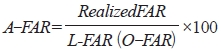
Land use and floor area ratio (FAR) (or, density) in a city are determined by such various situations as parcels, regulations, and urban tissues (Kweon and Kahng, 1995; 1996). A floor area ratio by law (hereafter, L-FAR) for each zoning has been regulated as an urban planning tool to manage density and sometimes land use, also. Despite the increasing pressure for urban developments and demands for density increase, not all parcels achieve the maximum building capacity to reach L-FAR. It is necessary to know which parcel conditions resulted in higher FAR. This study used the achieved floor area ratio (A-FAR),1) which represents the realized floor area ratio to L-FAR, as an indicator of the degree of realized developments by each parcel’s conditions as Kim and Choi, 2019 suggested. In the case of Seoul, the average A-FAR is about 70% (Kim and Choi, 2019). Even within the same zoning regulation, the A-FAR could be different as building types and parcels’ conditions change, but few literature has focused on the factors which affect the A-FAR.
To examine factors affecting the FAR achievement of individual parcels, previous studies have been conducted in two broad directions: simulation model development and empirical studies. The simulation studies (Kahng, 1983, 1984; Choi, 1997; Choi and Kahng, 1990; Kahng and Choi, 1994) confirmed that the permissive, or permissible, floor area ratio (P-FAR) changed depending on parcels’ various conditions such as front road, sunshine and sky exposure plane control, and urban tissues. Although those studies found that the parcel’s size and depth, front road width would affect P-FAR, they have some limitations that the reality was not fully considered. Empirical studies (Lee et al, 2009; Lee et al, 2010; Yun and Nam, 2013; Kim and Choi, 2019; Lee and Kim, 2002) attempted to find the possible factors to impact the achieved FAR on several sample cases. These studies found that the degree of the achieved FAR differed depending on the type of buildings and the zoning. However, these studies had the limitation that they studied on only limited areas, building types, and spatial units.
In the case of Seoul, about 75% of the buildings (454,822 of 604,726 dongs, as of 2018) are for residential use, and 53% of the total area of the city (326km2 of 605km2, as of 2018) is designated as a residential area. Given that, understanding the residential use and zoning is crucial and in-depth studies are necessary to plan and mange the city. Because the city has been formed and changed in close relation with the residential area and buildings, understanding of residential buildings (areas) should be cirtical (Sohn and Shin, 2003).
Housing types tend to be determined or changed by a combination of housing policy, demand, historical conditions of the region, physical environment, and characteristics of the residents. In recent years, practical interests as well as academic researches in Korea have mostly focused on apartments (condominium in USA). Row houses (Yeolrip-jutak), multi-household houses (dagagu-jutak), multi-dwelling houses (dasedae-jutak) and city-typed houses (dosihyung-saenghwal-jutak) have substantially contributed to the supply of housing to meet diverse demands. They are known to have problems such as lack of infrastructure and poor residential environment (Jang and Kang, 2011; Hong and Ahn, 2012), but it is necessary to consider that such variety of housing types play a positive role for the low-income class’s residential stability (Jang and Ahn, 2008). In understanding and planning cities, research on them is also necessary.
There have been many studies identifying that the degree of achieved FAR may vary depending on the type of house, but only limited studies have been conducted on differences in influencing factors. To distribute and manage various housing types, it is important to understand the factors and characteristics that determine such types. Depending on the housing type, the development scale may vary, because of external factors including legal, institutional, regional and parcel characteristics. In particular, individual parcel conditions would be a major factor influencing the realization of floor area ratio; depending on the characteristics of the parcel, the L-FAR may or may not be reached. The A-FAR is an index to confirm the degree of realization of the development. This shows how the market has reacted to each state, confirming that policies and regulations are being implemented to some extent.
This study aims to identify the factors influencing the A-FAR, focusing on individual parcel characteristics by most housing type such as detached, row houses, multi-household houses, multi-dwelling houses, apartments, and city-typed houses in Seoul. This attempt will contribute to understanding housing types and effective city management in consideration of the conditions of individual parcels. In addition, it will also be possible to use these as basic data since it is necessary to consider the characteristics of housing type in implementing housing policies.
Ⅱ.Literature review
1. Development characteristics by housing type
There have been a number of studies that have quantitatively and qualitatively analyzed the development status and spatial distribution characteristics for each housing types (Kim and Kim, 2007; Jang and Kang, 2011; Lee and Yang, 2012). Among others, some studies have tried to understand the characteristics of development of the city-typed houses, since it has appeared recently (You and Kim, 2015; Lee and Yang, 2012; Sung and Lee, 2015).
Previous studies have identified housing development patterns and changes by using time series analyses methods from the 1960s to the latest (Jang and Kang, 2011; Seong and Lee, 2016). Detached houses have decreased since the early 1990s, while many of those were demolished and redeveloped into multi-household and multi-dwelling houses (Kweon and Kahng, 1995; Kim and Kim, 2007; Koh and Ahn, 2010). Jang and Kang (2011) found that the detached houses were concentrated in city center areas (Jongno-gu and Gangbuk-gu) in the 1970s, but it gradually spread to outer areas (Gwangjin-gu, Dongjak-gu). After the 2000s, the number of detached houses increased mostly in areas with high income and land values, suggesting that the stratification is progressing even in the detached house.
Some studies were conducted on plans to achieve the FAR according to the structure and arrangement of lots for multi-household and multi-dwelling houses. Hong and Ahn (2012) found that the achieved FAR can be influenced by the area and angle of the lot, and that even a slight change in regulation can significantly affect the FAR in the case of small-scale lots. Jang and Ahn (2008) confirmed the optimal lot shape to achieve the maximum L-FAR while securing the maximum vacant land in lot for the multi-dwelling houses in the Class 2 general residential area, suggesting that the desirable lot arrangement would have the condition including the azimuth angle of the lot was 0°, the width 11 to 15m, and the area of the lot 250 to 320m2.
Lee and Nam (2020) attempted to identify the development characteristics and affecting factors for housing types, such as multi-household and multi-dwelling houses, in low-rise residential areas in Seoul during the period of 2005 to 2018. The results showed that the multi-one room houses were flocked in Gwanak-gu, multi-household houses in Gwangjin-gu, and multi-dwelling houses existed sporadically throughout the city, showing differences in spatial distribution. These houses were found to be bigger-scale than common detached houses at low prices, and highly likely to be developed in rectangular parcels.
For apartment houses, previous studies focused on factors that affect prices rather than analyzing development characteristics and influencing factors. Lee and Lee (2002) identified the characteristics of apartment development depending on the location of its position. It classified their findings into five regions of Seoul (city center, northwest, northeast, southwest, and southeast) and found that there were differences between the regions in terms of the number of frontage and the site shapes, etc. In subway catchment area, larger-scale complex, high-rise and high-density, and small-sized household development was found.
Koh and Ahn (2012) attempted to identify the development characteristics of small apartment complexes with fewer than 100 units. Small apartment complexes were mainly located in areas such as multi-household and multi-dwelling housing cluster areas, high-density residential areas, and subway catchment areas. The scale of development was found to be an average of about 10 stories and an average total floor area of 8,206m2, showing it is not matched with the surrounding buildings.
City-typed houses were introduced for the purpose of supplying small-sized units for 1 to 2 person households for their residential stability. They are clustered in Mapo-gu, Gangnam-gu, and Hwagok-dong in Seoul. The most of the city-typed houses were found to achieve L-FAR and be developed in small parcels (150-200m2) (Lee and Yang, 2012; You and Kim, 2015). Previous studies argued that the city-typed houses were mainly developed in such zones as the Class 2 general residential area and general commercial area. As multi-household and multi-dwelling houses, it can make poor residential environment in the future due to its high density (You and Kim, 2015).
Previous studies identifying the parcel characteristics and the factors affecting development by housing type are limited to some areas, making it hard to generalize their results. Those studies were confined to a single housing type or the development types, limiting comprehensive comparison and analysis of various housing types.
2. Understanding the realization of L-FAR
Studies examining the realization of L-FAR can be divided into simulation studies for estimating the permissible bulk and empirical studies identifying the factors that influence the realization of FAR. Kahng (1983, 1984) is the origin of the simulation studies, formulating mathematic simulation models with the relation between rectangular structure buildings and the sky exposure plane control of the frontage road in a square-shaped individual parcel. Under the sky exposure plane control, the larger the parcel size, the wider the width of the frontage road, and the smaller the number of the frontage roads can get higher permissive FAR. Later, Choi and Kahng (1990), Kahng and Choi (1994) divided the parcels in the same block size units based on condition of the parcel area and road width. As a result of simulating a 3D building shape in the parcel, it was confirmed that the permissive FAR varies depending on the lot and road conditions.
Choi (1997) estimated the permissible bulk including the capacity and shape of buildings according to the action of physical control factor by urban planning and design regulations. It found that the urban tissue was the first determining factor, and the legal building coverage ratio and L-FAR were the second. These simulation studies found that the conditions of individual parcel can affect the realization of the FAR.
Previous studies on the realization of the FAR found that infrastructure, land use, etc., were influencing factors determining the A-FAR in some case areas or administrative districts (Dong) (Kim, 1998a; Lee and Kim, 2002; Yun and Nam, 2013). Lee et al. (2009) looked at the characteristics of the parcel, such as the shape of the lot and the conditions of the frontage roads that affect the development density (realized/permissive FAR) for the two district unit planning. It found that the depth of parcel, width of frontage road, the number of frontage road, etc., were the major factors affecting development density.
Lee et al. (2010) divided the factors influencing the A-FAR into population, infrastructure, zoning, buildings, etc., by administrative district of Seoul. It was found that the A-FAR was higher in areas with good infrastructure and few detached houses.
Some studies looked into the influence on the realization of the FAR according to subdivided zoning; Lee and Kim (2002), Yoon and Nam (2013) focused on the residential area while Lee and Nam (2014) examined that of the commercial areas. Kim and Choi, 2019 studied residential and commercial areas together.
Lee and Kim (2002) analyzed the relation between the A-FAR and infrastructure for five residential districts. It found that the influence was not significant in the residential area, because the degree of regulaton impact varies depending on the conditions of the parcel and road. Lee and Nam (2014) analyzed the factors affecting the A-FAR in commercial areas by parcel, building, and regional characteristics as independent variables for each spatial structure of Seoul, showing that the realized FAR was relatively higher in the sub-centers of the city.
Kim and Choi, 2019 identified the factors affecting the A-FAR, focusing on the parcel characteristics in residential and commercial areas. Its results showed that the average A-FAR was higher in residential areas than in commercial areas, and the parcel characteristics also showed a meaningful result. It has been demonstrated that the degree of realization of the FAR was determined by the parcel and road conditions.
Yun and Nam (2013), Cheong et al. (2013) identified the factors affecting the A-FAR for the five region in Seoul. It was found that there was a difference in the influencing factors for each region; for example, the residential area or apartment had a positive (+) effect in all region except city center.
Studies on realization of FAR found that parcel characteristics were one of the major influencing factors for realizing FAR through simulation and empirical analyses. The studies that have categorized zoning type to identify the influencing factors, but only few have tried to consider residential building type.
3. This study’s differences
Previous studies on development characteristics by housing type focused on housing types such as detached housing, multi-household/multi-dwelling housing, and city-typed houses (Kim and Kim, 2007; Jang and Kang, 2011; Lee and Yang, 2012). On the other hand, few studies have identified factors affecting housing development by classifying housing types. In some studies, there was an analysis that included parcel characteristics as an influencing factor for housing development. Their results showed that the parcel characteristics played a role in the planning of housing and determining the FAR. However, a majority of studies had a limitation in drawing out general facts about all types of houses because their analyses were conducted only on a certain type of houses. Particularly, there was practically no study conducted both on detached houses type and multi-family houses type together. It can be assumed that the FAR would be the same for different housing types because the legal regulation to each housing type is different. Even with the same housing type, there will be differences in factors affecting the realization of the FAR, depending on the characteristics of the parcel and other conditions. For effective management and planning of residential area, a consistent analysis using the same data is required.
In simulation studies recognized the importance of parcel characteristics as they identified the influence of individual lot conditions in realizing FAR, but consideration of the building use was still insufficient. And the empirical studies mainly targeted single housing use, so few studies have conducted on factors affecting the realization of FAR by housing type. Most of the studies conducted analyses by categorizing the zoning, regions of Seoul, and spatial hierarchy, etc (Cheong et al, 2013; Lee and Nam, 2014; Kim and Choi, 2019). The usage of buildings may vary depending on the parcel conditions, regional characteristics, etc. Through this study, it will be possible to assume what purpose buildings can be built under certain conditions in individual parcels, and the results will contribute to effective urban management and real estate valuation.
Ⅲ. Methodology and variables
1. Scope and methodology
The scope of the study was the entire Seoul Metropolitan city. It used the building ledger (2016), taxation ledger (2015), and land characteristics survey (2015).
It should be noted that there are many missing values in the building ledger, as data recorded by hand was computerized around 2000. In the case of land characteristics survey, the purpose was to calculate the land price of individual land based on the standard land unit through data construction, therefore some attribute value omissions or numerical errors exist in the base year DB during the survey process. Despite these limitations, those data were used in this study since those were found to be the only data that reflect the detailed information of buildings and the characteristics of the individual parcel.
FAR, zoning area, building use, and parcel areas information, etc., were used as major variables for analysis of this study as far as parcel data were existed. If FAR is less than 50% and more than 1,500%, and land area is less than 30m2, they were considered as outliers and excluded from the analysis. After the data cleaning process, 162,567 parcels, of which the representative use is residential, were used for analysis among the total 967,845 parcels in Seoul, as of 2016 (see Figure 1).

Study area
For a multiple regression analysis, the A-FAR was set as a dependent variable and independent variables include the parcel characteristics, land use characteristics, and location characteristics. Housing types were classified into detached houses, multi-household houses, multi-dwelling houses, row houses, apartments in accordance with Attached Table 1 of the Enforcement Decree of the Building Act and city-typed houses based on the Housing Act.

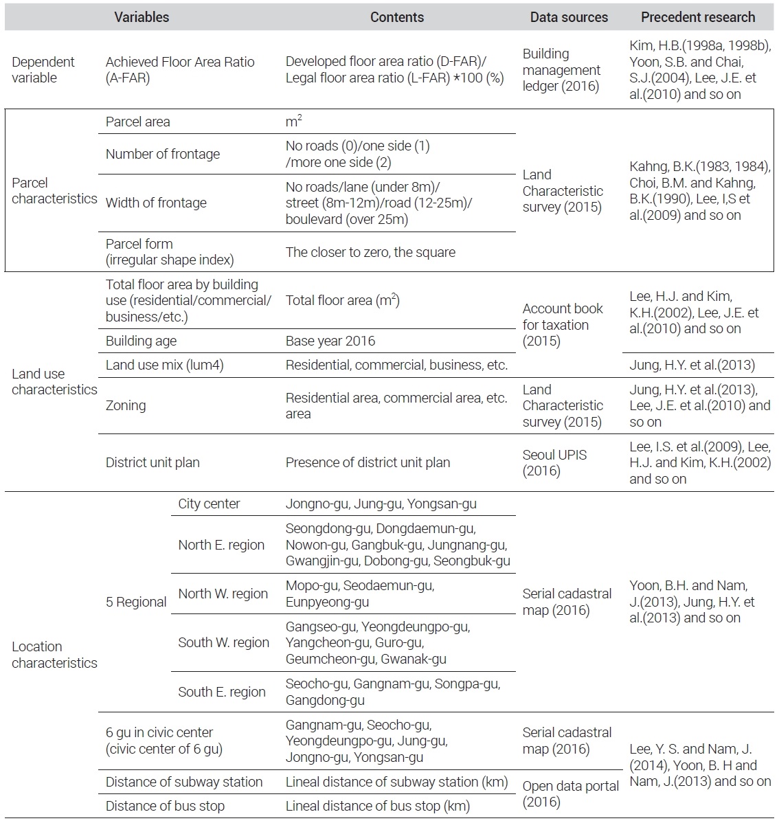
Variables and data sources
Detached houses generally mean a house for one household to live alone. However, the multi-household houses is legally designated a type of detached house type as the building and lot owned by an individual; it is less than three or four floors, and a total floor area of the house should be less than 660m2, has less than 19 units. The multi-dwelling house, which is legally considered a multi-family houses type and each unit can be owned by individuals, has less than 4 floors and its one building should be less than 660m2. The row house is a house having less than 4 floors and its one building bigger than 660m2. The apartment can have more than 5 floors. A city-type house can be constructed only in urban areas and its each unit should be less than public housing size (85m2) and it has less than 300 units. As such, because there are various legal standards for each housing type, when they are analyzed as one housing group, the characteristics of each are not known. To determine how the factors affecting the realization of FAR were different for various housing types, diverse models were formulated for each housing type.
2. Variables and data construction
The data and variables for parcel, land use, and location characteristics used in the previous studies were reviewed. Given the purpose of this study and data availability, the final variables were selected (See Table 1).
The A-FAR, the ratio of achieved floor area to L-FAR, was set as a dependent variable. The A-FAR was used in a number of preceding studies (Kim, 1998a, 1998b; Lee et al, 2010; Kim and Choi, 2019). Because the L-FAR for each parcel is different, it is not possible to know how much has been developed compared to each parcel L-FAR, if we only check the achieved FAR. However, if A-FAR is used, it can be understood to what extent it has been developed compared to L-FAR. This study used Seoul city’s FAR ordinance as L-FAR, because each municipality in Korea made their own ordinance which must be less than L-FAR of each zoning (Kim and Choi, 2019).
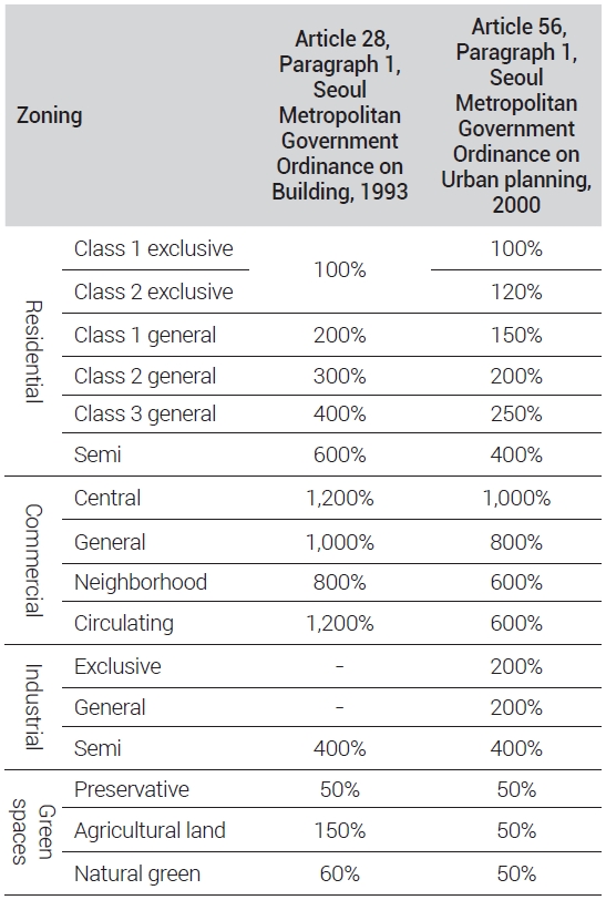
The zoning system in Seoul was reformed in 2000, so the L-FAR criteria before and after 2000 are different.2) The A-FAR was calculated with applicable L-FAR for the building’s completion approval date either before or after the year of 2000. Because sometimes a lot has multiple uses within it, the use that occupies the largest percentage of the total floor area of each lot was set as the representative use.
The parcel characteristic variable is the most important variable used in this study. The parcel size and road adjoining conditions can affect the degree of regulations and the types of buildings (Kahng, 1983; Choi and Kahng, 1990; Lee and Kim, 2002). The parcel area, the number of frontages, the width of frontage, and the form of parcel were defined as independent variables to find their levels of influence on A-FAR. The parcel area is used together with the squared parcel area to check the non-linear relationship between the A-FAR and the parcel area. Previous studies found that the smaller the parcel size had positive impact on the FAR and the A-FAR (Kim and Choi, 2019; Lee and Nam, 2014). The number and the width of frontage road have been mainly addressed in simulation studies, but rarely in empirical studies. So, they were used for this study.
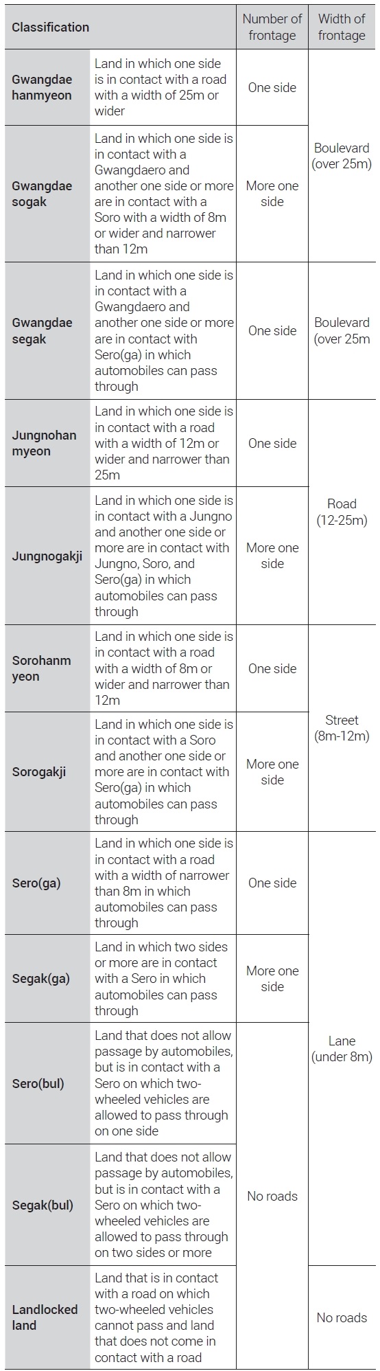
The number and the width of frontage road variable was reset based on the road condition(frontage) of land characteristics survey data.3) The number of frontages were categorized into 1) No roads, 2) One side, and 3) More one side. and The Width of frontage were divided 1) No roads, 2) Lane, 3) Street, 4) Road, 5) Boulevard.
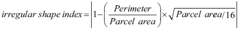
For irregular shape index of parcel,4) a formula utilizing the parcel area and perimeter was used, as suggested by Lim (2006) by modifying the optimum shape index of Yang and Joo (1995). The closer the index is to 0, the squarer it is, and the farther from 0, the greater the degree of irregular shape. It cannot be an absolute criterion since the square form index is a relative value, but it can still be used as a useful basis for understanding the parcel form within the scope of the space (Lee et al., 2009).
Since the land use characteristic variable and the location characteristic variable are expected to directly or indirectly affect the A-FAR, those were used as control variables. In the land use characteristics variable, the total floor area by building use was set. There are many cases in which a lot has very different kinds of uses. Assuming that the usage of the building in the lot would affect the realization of the FAR, the total floor area for each land use (residential, commercial, business, and etc.) was used as variables. Land Use Mix (LUM) index5) was used as a variable to examine the degree of land use mix in the individual lots. To identify the influence of the zoning characteristics, zoning (residential, commercial, other zones) was used as a variable as well.
The district unit plan, a kind of legal urban design in Korea, could have various regulations for each lot such as building use and size, and incentive scheme. It can significantly influenced A-FAR, so it was controlled as a dummy variable.
Location characteristics included accessibility to transit infrastructure and real-estate sub-market. As for distances to nearest subway station and bus stop were used. The linear distance from the centroid of the individual parcels to the nearest public transport using the “Near” command in ArcGIS was used as a variable. The housing sub-market in Seoul showed different characteristics, so five regions were used as variables. The regions of Seoul can be classified into the city center (Jongno-gu, Jung-gu, Yongsan-gu), the southeast region (Seocho-gu, Gangnam-gu, Songpa-gu, Gangdong-gu), the northeast region (Seongdong-gu, Dongdaemun-gu, Nowon-gu, Gangbuk-gu, Jungnang-gu, Gwangjin-gu, Dobong-gu, Seongbuk-gu), southwest region (Gangseo-gu, Yeongdeungpo-gu, Dongjak-gu, Guro-gu, Geumcheon-gu, Gwanak-gu) and northwest region (Mapo-gu, Eunpyeong-gu, Seodaemun-gu). Among those, 6 gu (Seocho-gu, Gangnam-gu, Yeongdeungpo-gu, Jongno-gu, Jung-gu, Yongsan-gu) of three central business districts (Hanyangdosung, Yeouido and Yeongdeungpo, Gangnam) under 2030 Seoul Plan were selected as variables, because these were areas where development demand is higher than other areas.
Ⅳ. Analysis of factors affecting A-FAR by housing type
1. Descriptive analysis
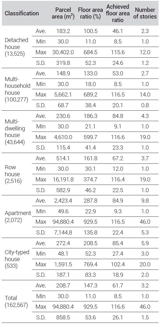
Descriptive analysis were examined to find the development characteristics of each housing type(see Table 2). Of the total 162,567 parcels, multi-household houses accounted for about 62% with 100,277 parcels, followed by multi-dwelling houses (26.7%) and detached houses (8.3%). These three type of housing occupied a significantly high ratio.
Descriptive analysis by house type
The average parcel area of apartment houses accounted for the largest proportion with 2,423.4m2, followed by row houses (514.1m2), city-typed houses (272.4m2), multi-dwelling houses (230.6m2), detached houses (183.2m2), and multi-household houses (148.9m2). Apartment houses were developed on a larger lot, or site, compared to other houses. Detached houses were built on a larger parcel than multi-household, and it is highly likely that the former will be converted into the latter in the future. Otherwise, it is presumed that some detached houses have existed in the luxury housing market (Jang and Kang, 2011).
The city-typed houses had the highest A-FAR (85.4), followed by apartments (84.9), multi-dwelling houses (84.8), row houses (67.2), multi-household houses (53.0), and detached houses (46.1). The Multi-family houses type’s A-FAR has more than 80, except row, showing a high achievement rate, while that of the detached and multi-household houses—which are classified as detached houses type—were less than 60. This result came from the differences in the legally regulated size for each housing type, signifying decent reliability of data used in this study. The average number of stories was the highest in apartment (9.8 floors), followed by city-typed house (5.9 floors), multi-dwelling house (4.3 floors), row house (3.7 floors), multi-household house (2.7 floors), and detached house (2.3 floors). In the case of apartments, the standard deviation was 5 floors, showing that the difference in the number of floors was relatively large.
2. Regression analysis
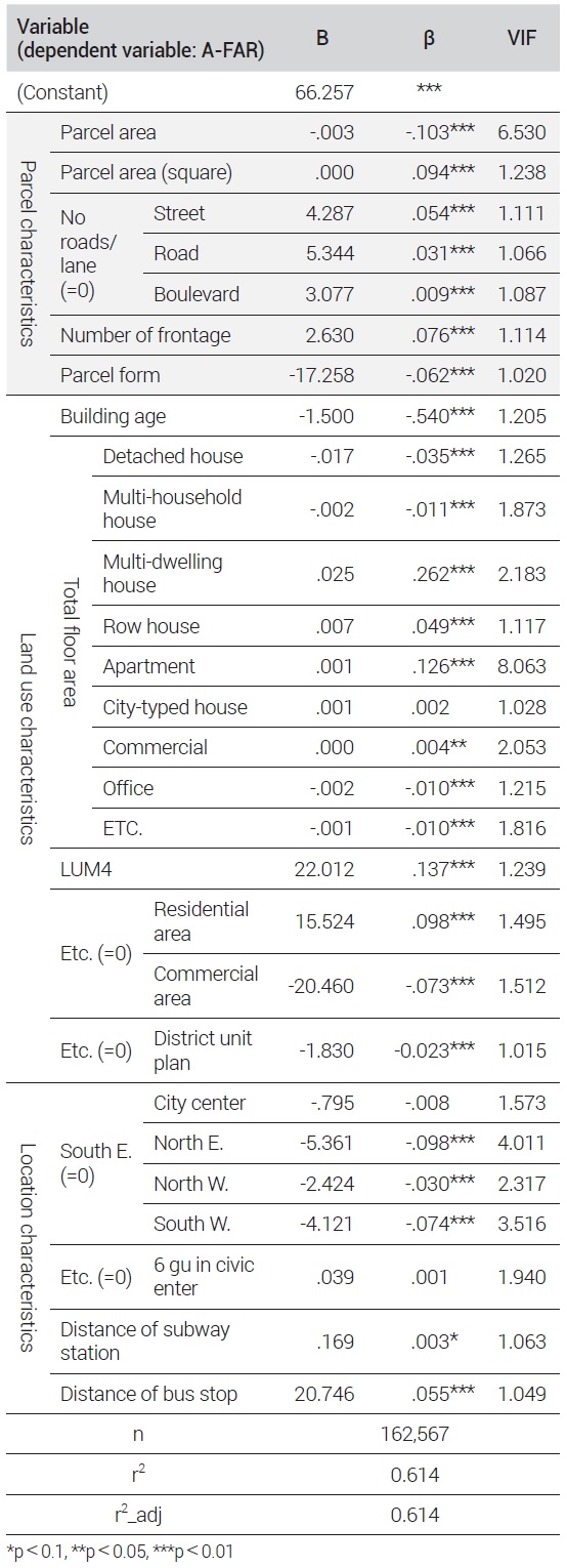
First, this study attempted to identify the factors influencing the A-FAR for all houses in Seoul. As the conditions of individual lots affect the A-FAR, the focus was on the parcel characteristics (Kahng, 1983, 1984; Lee and Kim, 2002).
The adjusted r-square of the model was 61.3%, and the VIF (Variance Inflation Factor) of all variables was less than 10, showing there was no critical multicollinearity issue (see Table 3).
Analyzing the influence factor of A-FAR of all residential type(multiple regression analysis)
The A-FAR increased as the parcel area decreased. To examine this, Kim and Choi, 2019 divided the parcel areas into four categories: large, medium-large, medium-small, and small areas, but it had the limitation that the criteria was not objective enough. This study looked into the non-linear relation between the A-FAR and the parcel area by using the square of parcel areas. The results showed that for the entire houses in Seoul, the parcel areas and the A-FAR had a positive (+) quadratic relationship, as the A-FAR increased as the parcel area decreased, and from a certain point, the A-FAR increased too as the parcel area gets larger.
As for the width of frontage, the values of “no roads” and “lane” were combined and set as a reference variable. The model showed that the A-FAR increased as the width of the road got larger. Kim and Choi, 2019 on all building type, empirically found that the road/street had a more positive influence on the A-FAR than boulevard. But, In this study targeting only residential buildings, the A-FAR increased as the road width increased, showing similar results to some previous studies (Kahng, 1983, 1984; Lee, et al, 2009).
The more the number of road and the closer the parcel form to the square, the more positive impact was made on the A-FAR. Kahng (1983, 1984) which conducting the mathmatical simulation argued that the less the number of road, the higher the permissive FAR would get because of the sky exposure plane control. However, in this empirical model, it was found that the more the number of roads, the more positive influence on the A-FAR. On the parcel form, this model showed that the FAR was higher in square-shaped parcels than indeterminate-formed parcels, as previous studies showed (Lee et al, 2009; Ko, 2016; Kim and Choi, 2019).
It was confirmed that the more recently built buildings, the higher the A-FAR. The effect of total floor area on A-FAR differed depending on the type of housing. t the A-FAR increased as the total floor area of detached houses type (detached/multi-household houses) smaller and that of multi-family housing type (multi-dwelling/row/apartment/city-typed houses) larger.
Based on this, it can be assumed that different housing types would have different influences on the A-FAR. The A-FAR increases as the commercial total floor area is larger, but the business and other use total floor area is smaller. The A-FAR increased when the land use within the parcel is relatively highly mixed as LUM is high. Interestingly the A-FAR was found to be higher in residential areas than other areas.
In the location characteristics, the results showed that the A-FAR was significantly lower in northeast, northwest, and southwest regions than southeast region. This means that the housing development is more actively achieved in the southeast region to meet housing demand for that region. Because there may be differences in variables affecting the A-FAR for different housing types, we tried to divide the analyses results into detached houses type and multi-family houses type.
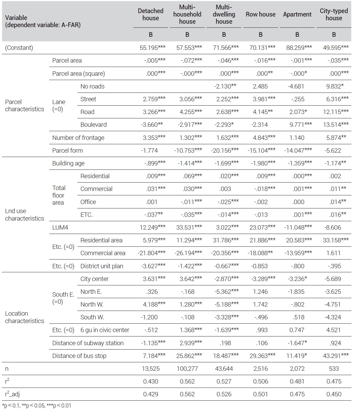
Detached house type were categorized into detached houses and multi-household houses (see Table 4). The parcel area of a detached house and the A-FAR have a positive (+) non-linear relation to A-FAR. This is because the high-end detached houses in large parcels has lower A-FAR. For detached houses and multi-household houses, the A-FAR increased as the parcel area became smaller. The A-FAR rised in street/road compared no road/lane, while it relatively decreased in boulevard. It can be know that the higher A-FAR can be obtained when the detached house was built around a backside road than a main street. For all detached house types, the A-FAR increased as the number of frontages road rose. Just for the multi-household houses, the A-FAR increased when the parcel form was relatively closer to a square. The frontage characteristics showed a similar trend in all detached housing types, while the parcel form and parcel area showed different characteristics.
Analyzing the influence factor of A-FAR of all residential type(multiple regression analysis)
As for the land use characteristics variables, the A-FAR became higher when the building age is younger. As for the building use within the parcel, the greater the residential and commercial total floor area are, the higher the A-FAR. It can be assumed that the A-FAR would be relatively higher for a house having commercial use together. LUM showed a positive (+) relationship to A-FAR, showing that the latter increased when the degree of land use mix got higher. As for the zoning, the A-FAR was higher in residential areas than other zones. The A-FAR was higher in the case of non-district unit plan because the plan usually have stronger L-FAR regulation or other restriction to developments.
For the location characteristics, the A-FAR showed more positive in city center and northwest regions than in the southeast region both for detached and multi-household houses, while there was no significant influence observed in the northeast and southwest regions. For the multi-household housing, the A-FAR was found to be higher in the 6 gu in CBDs. This is presumed to be because the multi-household housing development demand is higher in the districts.
Regarding the detached houses, the closer the distance to the subway station and the farther the distance to the bus stop, the higher the A-FAR. For the multi-household houses, the A-FAR was higher when the distance to the subway station and bus stop was farther. These results are different from the beliefs and hopes that the closer to transit, the higher the density will be. A more in-depth study is needed on this.
The parcel areas of multi-family houses types have the non-linear relationship to A-FAR (see Table 4). In case of apartment, the A-FAR has the negative (−) quadratic relationship to the parcel area as A-FAR increased to a certain level as the latter area did, but decreased after a size of lot. Other multi-family houses including multi-dwellings, row, and city-typed housing types shown the opposite results from apartments. The have the positive (+) quadratic relationship to the parcel area. Although all apartments want to achieve L-FAR, it is presumed that if the site is larger, it is more subject to strong regulations.
In the case of multi-dwellings and row houses, A-FAR increased when frontage width was adjacent to street/road rather than lane or to lane rather than boulevard. This means that the multi-dwellings and row houses are being developed by achieving L-FAR in the inner block or the back road of the boulevard. City-typed houses had an increased A-FAR when facing no roads, street, road, and boulevard rather than Lane. This means that it is positive for A-FAR when the frontage conditions are relatively good. City-typed houses has relatively low importance in accessibility by car, so development of combine lots with no road parcel may occur to secure business feasibility (You and Kim, 2015) Therefore, it is presumed that the A-FAR was relatively high in the no road.
For apartment houses, the A-FAR was higher in road and boulevard, meaning that the A-FAR is relatively higher in places with good accessibility. As such, it was found that the differences in frontage width for various housing types can affect the A-FAR. In multi-family houses type except apartment, the greater the number of frontages, and more positive influence made on the A-FAR.
In addition, the closer the parcel form to a square, the more positive influence made on the A-FAR in all multi-family housing, except for the city-typed houses.
For the land use characteristics, the younger the building age, the more positive effect on the A-FAR in all multi-family houses type. The effect of land use within a pacel on A-FAR was different for all housing types. Multi-dwelling houses and row houses had a positive effect on A-FAR when the residential use increased and the other uses decreased. This means that the A-FAR increases when other uses on the parcel are not mixed in the both housing types. For apartment houses, it looked the A-FAR was higher when the commercial, and other total floor area increased.
However, the LUM in a parcel showed a negative (−) value in apartment, showing that the smaller the number of usages of a building in a lot, the more positive impact made on the A-FAR. City-typed houses showed that LUM is not effective, but the commercial, business, and other total floor area could contribute the A-FAR.
As for the zoning, multi-dwelling houses, row houses, and apartments showed higher A-FAR in the residential area than in other areas. CIty-typed houses presented a different result as the commercial area showed a relatively higher A-FAR than the residnetial area.
The A-FAR in the multi-dwelling houses was relatively higher when they are designated by the district unit plan, but the others have higher A-FAR when there are no regulation by the plan.
On location characteristics, most of the multi-family houses type showed a higher A-FAR when in the southeast region, unlike the cases of detached houses type. In the southeast region, the average A-FAR of the multi-family houses type was about 70 to 90, which was the highest compared to other regions. Because of housing demand, the development of the multi-family houses is relatively active in the southeast area compared to other regions. In the case of multi-dwelling housing, the A-FAR was relatively higher in the southeast region than in other areas. For row houses and apartments, the A-FAR was higher in the southeast region than in the city center, and other regions showed no significant results. There was no significant result observed for the city-typed housing, showing that there was no difference between regions. Only in multi-dwelling houses, the A-FAR was higher in the areas other than the top 6 gus, showing that the development of multi-family houses is relatively active in areas other than the city center. In terms of accessibility to public transport, the farther the distance to the bus stop, the higher the A-FAR. As for the distance to subway stations, the A-FAR increased as the distance got closer only in apartment, suggesting that the accessibility to subway station is relatively important factor in apartment houses.
Ⅴ. Conclusion
This study aims to identify the factors influencing the A-FAR, focusing on the parcel characteristics by housing type such as detached, multi-household, multi-dwelling, row, and city-typed houses as well as apartment. It found that there are differences in parcel characteristics that affect the A-FAR by house type as following.
First, the level of A-FAR differed depending on the housing type. The overall A-FAR of houses was about 70.9, and there was a difference between individual housing types. The A-FAR was the highest in the city-typed (85.4), followed by apartments (84.9), multi-dwelling houses (84.8), row houses (67.2), multi-household houses (53.0), and detached houses (46.1).
Secondly, the A-FAR in the multi-household and apartment houses increased as the parcel area decreased. On the other hand, detached, multi-dwelling, row, and city-typed houses showed that the A-FAR was in a positive (+) quadratic relationship with the parcel areas. For these housing types, the parcel areas over certain ones had a positive influence on the A-FAR.
Thirdly, on the effect of the width of frontage road, the A-FAR was found to be higher in detached, multi-household, multi-dwelling, and row houses in street/road than in (no road)/lane. For the apartment and city-typed houses, the street/road showed a more positive influence on the A-FAR than the lanes, suggesting that the A-FAR is higher in places facing wider road (instead of the backside roads) with good accessibility. In all houses except for apartments, the larger the number of frontage roads, the more positive impact on the A-FAR, suggesting that apartments are less affected by the number of roads.
This study is meaningful because it identified for the entire city of Seoul that there are differences in parcel characteristics for various housing types in realizing the FAR. Based on these findings, it will be possible to determine which type of housing is appropriate to develop for the applicable parcel characteristics. By efficiently utilizing individual lots and predicting and presenting the direction required in urban planning and design stage. It will be possible to contribute to narrowing the gap of perspectives from urban planning and the real estate market.
Nevertheless there are several limitations in this study. Because the study conducted only on housing types, other building uses were not considered. Also, the FAR is controlled separately for residential complexes in commercial areas, but it was not considered due to limited data. The impact of changes in laws and systems such as sky-exposure plane control and district unit planning guidelines was not sufficiently considered as well. In particular, in the case of district unit planning, the influence of incentives per detailed guidelines for each area was not reflected. Therefore, it will be necessary to conduct a follow-up study that considers legal, institutional, and policy factors as well.
Acknowledgments
This study was sponsored by the National Research Foundation of Korea with research funds from the Ministry of Science and ICT, Korea (NRF-2020R1A2C1008509, NRF-2019R1H1A2079960).
This paper is a translation of a paper written in Korean into English, and a Korean version is released on the website(www.kpa1959.or.kr).
Notes
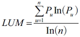 Pu: Ratio of area by use (u), n= Number of use
References
-
Cervero, R. and Kockelman, K., 1997. “Travel Demand and the 3Ds: Density, Diversity, and Design”, Transportation Research D, 2(3): 199-219
[https://doi.org/10.1016/S1361-9209(97)00009-6]

-
Cheong, H.Y., Lee, H.J., Kim, H.R., and Lee, M.H., 2013. “A Study on the Characteristic of Realization Ratio of Floor Area Based on Zoning –Focused on 5 Seoul Urban Zones of 2030 Urban Master Plan(Possible Agenda)–”, Journal of Korea Planning Association, 48(5): 233-249.
정혜영·이혜주·김혜란·이명훈, 2013. “용도지역을 고려한 용적률 실현 특성에 관한 연구 –2030 서울시 도시기본계획(안)에 따른 5대 생활권을 중심으로–”, 「국토계획」, 48(5): 233-249. -
Choi, B.M. and Kahng, B.K., 1990. “Estimation and Control of the Development Capacity in the Urban Block”, Journal of Korea Planing Association, 25(1): 67-91.
최봉문·강병기, 1990. “가구개발용량의 예측과 조정에 관한 연구”, 「국토계획」, 25(1): 67-91. -
Choi, C.G., 1997. “An Analysis of the Controlling Mechanism of Urban Spaces by Simulating Permissible Bulk”, Ph.D. Dissertation, Hanyang University.
최창규, 1997. “개발용적 시뮬레이션 모형을 활용한 물적제어의 작용구조 해석”, 한양대학교 박사학위논문. -
Hong, S.J. and Ahn, K.H., 2012. “FAR Changes in Securing Distance between Buildings & Open Spaces of Multi-Family Housings”, Journal of The Architectural Institute of Korea Planning & Design, 28(8): 161-168.
홍성조·안건혁, 2012. “다세대·다가구 주택의 이격거리 및 오픈스페이스 확보에 따른 용적률 변화에 관한 연구”, 「대한건축학회논문집–계획계」, 28(8): 161-168. -
Jang, J.I. and Ahn, K.H., 2008. “A Study on the Lot Arrangement of Multi-Family Housing by a Lot Design Model”, Journal of the Urban Design Institute of Korea Urban Design, 9(3): 41-54.
장재일·안건혁, 2008. “획지계획모형을 적용한 다세대주택용 획지 배치에 관한 연구”, 「도시설계」, 9(3): 41-54. -
Jang, M.J. and Kang, C.D., 2011. “The Spatial Patterns of Single Family Housing in Seoul 1970~2009”, Seoul Studies, 12(2): 19-40.
장명준·강창덕, 2011. “서울시 단독주택 공간분포 연구(1970~2009)”, 「서울도시연구」, 12(2): 19-40. -
Kahng, B.K., 1983. “The Attainable Floor Area Ratio under Sky Exposure Plane Control”, Journal of Korea Planning Association, 18(1): 3-10.
강병기, 1983. “사선제한하에서 달성가능한 용적비 –용적률에 관한 연구(Ⅰ)–”, 「국토계획」, 18(1): 3-10. -
Kahng, B.K., 1984. “The Attainable Floor Area Ratio under Sky Exposure Plane Control”, Journal of Korea Planning Association, 19(2): 45-58.
강병기, 1984. “용적률에 관한 연구(Ⅱ) –사선제한을 받는 용적비의 일반식–”, 「국토계획」, 19(2): 45-58. -
Kahng, B.K. and Choi, B.M., 1988. “The Study on the Attainable Floor Area Ratio(F.A.R) under Sky Exposure Plane Control”, Journal of Korea Planners Association, 23(2): 21-40.
강병기·최봉문, 1988. “도로와 인접대지경계선에서 사선제한을 동시에 받는 단일대지의 용적률”, 「국토계획」, 23(2): 21-40. -
Kim, H.B., 1998a. “An Actual Analysis on the Floor Area Realization Ratio of Buildings in Commercial District”, Journal of Korea Planning Association, 33(4): 89-104.
김형보, 1998a. “상업지역 건축물의 용적율 실현정도에 관한 실증분석”, 「국토계획」, 33(4): 89-104. -
Kim, H.B., 1998b. “An Analysis of Influence by Development Subject in Floor Area Realization Ratio of Office Buildings”, Journal of The Architectural Institute of Korea Planning & Design, 14(8): 107-115.
김형보, 1998b. “개발주체가 오피스 용적실현비에 미치는 영향 분석”, 「대한건축학회 논문집–계획계」, 14(8): 107-115. -
Kim, H.B. and Kim, H.W., 2007. “Study on the Transformation Characteristics of Building-type and Single Detached Housing Area in Urban”, Journal of The Architectural Institute of Korea Planning & Design, 23(10): 21-28.
김홍배·김형우, 2007. “도시 단독주택지 및 건축형식의 변화특성에 관한 연구”, 「대한건축학회 논문집–계획계」, 23(10): 21-28. -
Kim, S.H. and Choi, C.G., 2019. “Urban Tissue, Zoning and Achieved Floor Area Ratio (A-FAR) –Focused on Developed Floor Area Ratio (D-FAR) Compared to the Legal Floor Area Ratio (L-FAR) in Residential Area and Commercial Area in Seoul–”, Journal of Korea Planning Association, 54(2): 33-45.
[
https://doi.org/10.17208/jkpa.2019.04.54.2.33
]
김수현·최창규, 2019. “용적실현비(A-FAR)에 영향을 미치는 용도지역별 대지특성에 대한 분석 –서울시 주거지역 및 상업지역에서 법정용적률(L-FAR) 대비 실현된 용적률(D-FAR)을 중심으로–”, 「국토계획」, 54(2): 33-45. -
Koh, S.B. and Ahn, K.H., 2010. “A Study on the Transitional Characteristics of the Ratio of Housing Type in Korea”, Journal of The Architectural Institute of Korea Planning & Design, 26(8): 45-54.
고세범·안건혁, 2010. “우리나라 주택유형 비율의 변화 특성에 관한 연구”, 「대한건축학회 논문집–계획계」, 26(8): 45-54. -
Koh, S.B. and Ahn, K.H., 2012. “Investigating the Development and Location Characteristics of the Apartment Complex under 100 Households in the Residential Block in Seoul”, Journal of The Architectural Institute of Korea Planning & Design, 28(7): 79-89.
고세범·안건혁, 2012. “서울시 도시 가구(街區)내 10세대 미만 소형아파트단지의 개발 및 입지 특성 연구”, 「대한건축학회 논문집–계획계」, 28(7): 79-89. -
Ko, Y.S., 2016. “A Comparative Analysis of Floor Area Ratio according to the Standardization of Small-size Irregular Parcels”, Master’s Degree Dissertation, Seoul National University of Science and Technology.
고영수, 2016. “소규모 부정형 필지의 정형화에 따른 건축용적률 비교 분석 연구”, 서울과학기술대학교 주택대학원 석사학위논문. -
Kweon, I. and Kahng, B.K., 1995. “The Development Sequence of a Newly Developed Urban Area, in the Case of Kangnam, in Seoul”, Journal of Korea Planning Association, 30(4): 93-109.
권일·강병기, 1995. “신시가지 토지이용변화의 발생순서에 관한 실증적 연구(Ⅰ) –서울시 강남 신시가지를 대상으로–”, 「국토계획」, 30(4): 93-109. -
Kweon, I. and Kahng, B.K., 1996. “The Conditional Factors of a Parcel Affect the Parcel Development Timing in a Newly Developed Urban Area. in the Case of Kangnam, Seoul”, Journal of Korea Planning Association, 31(2): 47-59.
권일·강병기, 1996, “신시가지 토지이용변화의 발생순서에 관한 실증적 연구(Ⅱ) –획지조건의 복합적 작용하에서 획지의 개발시기 분석을 중심으로–”, 「국토계획」, 31(2): 47-59. -
Lee, C.K. and Lee, J.H., 2002. “Analysis of Apartment site Development Characteristics in Metropolitan Areas: Concerning Location and Development Characteristics”, Journal of Korea Planning Association, 37(5): 113-126.
이천기·이주형, 2002. “입지별 아파트단지 개발특성 분석”, 「국토계획」, 37(5): 113-126. -
Lee, H.C. and Kim, K.H., 2002. “A Study on the Characteristics of Development Density Pattern in Residential Zone for the Purpose of Classified Zoning Control in Seoul”, Journal of Korea Planning Association, 37(5): 161-176.
이희정·김기호, 2002. “서울시 일반주거지역 세분을 위한 주거지 밀도분포 특성 연구(2) –지구단위 건축밀도 분포패턴과 특성분석을 중심으로–”, 「국토계획」, 37(5): 161-176. -
Lee, H.S. and Yang, S.W., 2012. “The Development Pattern of Urban Multi-Family Housing in Seoul”, Journal of The Architectural Institute of Korea Planning & Design, 28(11): 291-301.
이현숙·양승우, 2012. “서울형 도시형 생활주택의 개발특성에 관한 연구”, 「대한건축학회 논문집–계획계」, 28(11): 291-301. -
Lee, I.S., Lim, S.J., and Kim, C.S., 2009. “Analysis of the Effect of Parcel Shape on the Development Density–A Case Study of Chun-ho·Am-sa District”, Journal of the Urban Design Institute of Korea Urban Design, 10(4): 151-162.
이인성·임상준·김충식, 2009. “필지형상이 개발밀도에 미치는 영향 분석–서울시 강동구 천호·암사 지구단위계획구역을 대상으로”, 「도시설계」, 10(4): 151-162. -
Lee, J.E., Lee, S.H., and Lee, M.H., 2010. “Analyzing the Realized Characteristics of Development Density in Seoul”, Journal of Korea Planning Association, 45(5): 53-63.
이지은·이소희·이명훈, 2010. “서울시 개발밀도 실현특성에 관한 연구”, 「국토계획」, 45(5): 53-63. -
Lee, J.H. and Nam, J., 2020. “A Study on the Factors Affecting the Development of Housing Types in Low-Rise Residential Area in Seoul”, Journal of Korea Planning Association, 55(1): 35-53.
[
https://doi.org/10.17208/jkpa.2020.02.55.1.35
]
이정현·남진, 2020. “서울시 저층주거지의 주택유형별 개발에 미치는 영향요인에 관한 연구”, 「국토계획」, 55(1): 35-53. -
Lee, Y.S. and Nam, J., 2014. “A Study on the Influence Factors of Development Density of Commercial District in Seoul”, Journal of Korea Planning Association, 49(8): 63-77.
[
https://doi.org/10.17208/jkpa.2014.12.49.8.63
]
이윤상·남진, 2014. “서울시 상업지역의 개발밀도에 미치는 영향 요인 연구”, 「국토계획」, 49(8): 63-77. -
Lim, S. J., 2006. “Analysis of the Factors of Development Density According to the Morphological Characteristics of Land Parcels”, Master Dissertation, University of Seoul.
임상준, 2006. “대지의 형태적 특성에 따른 개발밀도 영향요인의 분석 –서울시 강동구 천호·암사지구단위계획지구를 중심으로–”, 서울시립대학교 석사학위논문. -
Seong, E.Y. and Lee, H.Y., 2016. “The Spatial-Temporal Patterns and the Classification of Single Family Housing Clusters in Seoul”, Seoul Studies, 17(4): 33-57.
성은영·이희연, 2016. “서울시 단독주택 밀집지구의 시공간 패턴과 유형화”, 「서울도시연구」, 17(4): 33-57. -
Sohn, S.K. and Shin, J.H., 2003. “A Study on the Spatial Structure of Residential Block in Seoul”, Journal of The Architectural Institute of Korea Planning & Design, 19(4): 83-90.
손세관·신진희, 2003. “서울 주거지역내 주거블록의 공간구조에 관한 연구”, 「대한건축학회 논문집–계획계」, 19(4): 83-90. -
Sung, D.J. and Lee, K.K., 2015. “A Study on the Location and Development Characteristics of the Urban-type Housing in Busan”, Journal of the Regional association of architectural Institute Of Korea, 17(4): 53-62.
성도재·이광국, 2015. “부산시 도시형 생활주택의 입지 및 개발 특성에 관한 연구”, 「대한건축학회연합논문집」, 17(4): 53-62. -
Yang, S.W. and Ju, J.W., 1995. “A Study on the Physical Characteristics of Plots of C.B.D. of Seoul in the Late Choseon Dynasty”, Journal of Korea Planning Association, 30(4): 75-92.
양승우·주종원, 1995. “조선후기 서울도심부 필지의 형태적 특성에 관한 연구–1912년 완성된 경성부 지적원도를 중심으로”, 「국토계획」, 30(4): 75-92. -
Yoon, H.R. and Nam, J., 2013. “A Study on the Change of the Factors Affecting a Development Density in Seoul –Focused on the Before and After Comparison of the Sub-Classification of General Residential Zones (2002-2011)”, Journal of Korea Planning Association, 48(3): 165-180.
윤혜림·남진, 2013. “서울시 개발밀도에 영향을 미치는 요소의 변화에 관한 연구–일반주거지 종세분화 전, 후(2002-2011) 비교를 중심으로”, 「국토계획」, 48(3): 165-180. -
You, Y.S. and Kim, S.H., 2015. “The Development of Urban Residential Housing and Its Implications for Urban Design in Low-rise Residential Areas”, Journal of the Urban Design Institute of Korea Urban Design, 16(5): 59-76.
유영수·김세훈, 2015. “저층 주거지 내 도시형 생활주택의 개발 특성과 도시설계적 시사점”, 「도시설계」, 16(5): 59-76. -
Yun, B.H. and Nam, J., 2013. “A Study on the Factors Affecting Realization Rate of Development Density in Seoul”, Journal of Korea Planning Association, 48(5): 177-196.
윤병훈·남진, 2013. “서울시 개발밀도 실현율에 영향을 미치는 요인에 관한 연구”, 「국토계획」, 48(5): 177-196.